| WPC Met Watch |
|
|
Mesoscale Precipitation Discussion: #0845 (2018) |
|
(Issued at 532 PM EDT Sat Sep 15 2018
) |
|
| MPD Selection |
|
|
|
|
|

Mesoscale Precipitation Discussion 0845
NWS Weather Prediction Center College Park MD
532 PM EDT Sat Sep 15 2018

Areas affected...Southeastern NC and south-central
NC...northeastern to south-central SC

Concerning...Heavy rainfall...Flash flooding likely

Valid 152130Z - 160330Z

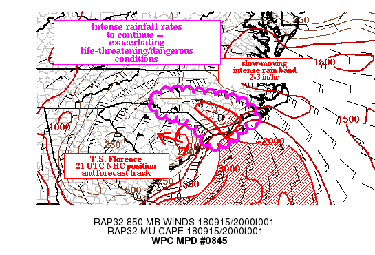
Summary...Rainfall bands east of Florence will continue to produce
torrential rainfall rates, exacerbating the already
catastrophic/life-threatening flooding conditions that exist
across portions of southeastern NC.  Over the next several hours,
additional amounts of up to 6-10 inches can be expected within the
core of the heaviest rainfall bands.

Discussion...At NHC advisory time, Florence had shown little
movement over the past 6-hours, drifting westward across
Williamsburg County, SC.  Composite reflectivity indicates the
persistence of banded heavy rainfall east of the center, with
increasing reflectivity within the band centered across Columbus
and Bladen counties.  Before becoming unavailable, KMHX radar was
showing estimated rainfall rates of 1.5 to 2 inches/hr within the
core of this band.  For the 6-hr period ending at 21 UTC,
estimates show 3-6 inch amount accumulations where the heavier
bands persisted from Brunswick to Bladen counties and from Pender
to Sampson counties, with estimates as high 9+ inches across
southern Blanden, northern Columbus and coastal Pender couties.
With Florence expected to continue its slow drift to the west this
evening into the overnight, expect little shift in the axis of
heaviest rains.  Given the availability of offshore instability
and persistent 50-60 kt low level inflow, supporting PWs of 2.25
to 2.75, the integrity of the heavier rain bands is not expected
to change much over the next several hours.

The mesoscale guidance has been too quick to retrograde the bands,
and recent radar trends show rain expanding back to the
east along the NC coast.  That said, the latest hi-res consensus
may be a little too far to the southwest with its axis of heaviest
amounts.  But overall confidence remains high for additional very
heavy rain amounts upwards of 6-10 inches from the Cape Fear
region northwestward toward Cumberland and Hoke counties over the
next several hours.  Elsewhere, across southeastern into
south-central NC and adjacent SC, hi-res guidance shows relatively
lighter but significant amounts through, which may result in
additional flooding concerns.

Pereira

ATTN...WFO...CAE...GSP...ILM...MHX...RAH...

ATTN...RFC...SERFC...

LAT...LON   35668049 35657953 35407803 35087715 34407672
            34317722 33757780 33417844 33537880 34177924
            34577984 34758080 35318112
Last Updated: 532 PM EDT Sat Sep 15 2018
|


