| WPC Met Watch |
|
|
Mesoscale Precipitation Discussion: #0846 (2022) |
|
(Issued at 633 PM EDT Mon Aug 22 2022
) |
|
| MPD Selection |
|
|
|
|
|

Mesoscale Precipitation Discussion 0846
NWS Weather Prediction Center College Park MD
633 PM EDT Mon Aug 22 2022

Areas affected...Southeast TX...Central & Western LA...

Concerning...Heavy rainfall...Flash flooding likely

Valid 222233Z - 230413Z

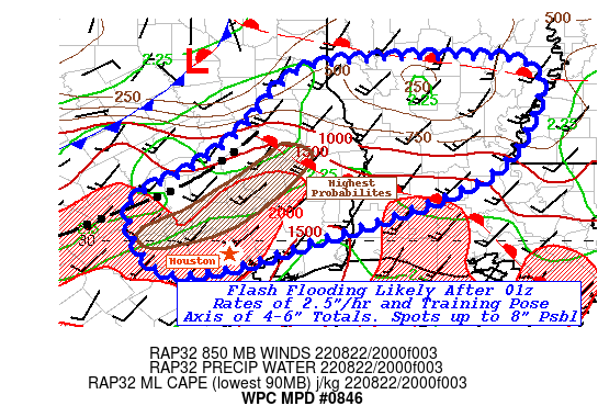
SUMMARY...Band of thunderstorms to reinvigorate and be slower
moving across SE TX into LA with 4-6" totals by 06z.  Flash
flooding likely.

DISCUSSION...22z Surface analysis denotes outflow
boundary/pre-frontal trof dropping south across much of central TX
from Cherokee to Bastrop county (and further west) with an
apparent developing/forming warm front angling from Cherokee SE
toward LCH to ARA.  The surface low continues to drop southeast
out of Henderson county with a dying warm front along I-20 in N
LA.  A few remaining embedded thunderstorms remain in the WAA
regime in northern and central LA, but much of the instability
have been worked over in favor of the very unstable air across SE
TX.  Low to mid 90s over mid to upper 70s Tds are available
supporting MLCAPEs of 2000-2500 J/kg in this sector feeding
ongoing thunderstorms on the outflow boundary.   Cold pool is
losing some forward steam and is expected to slow further perhaps
even stall as the evening ends.  The LLJ will strengthen and as
shortwave energy rotates around the western periphery of the
deeper shortwave/closed low over NE TX and helps to back sfc to
boundary layer flow increasing angle and strength of moisture flux
convergence along the length of the boundary/effective front.
Thunderstorms will restrengthen to very strong/very efficient
heavy rainfall producing line.  Rates of 2.5"+/hr are expected and
with slow southeastward propagation of the line while deep layer
steering flow is generally parallel to the boundary will support
training and rapidly increase a line of excessive rainfall across
the NW exurbs of the Houston Metro, perhaps into the suburbs
toward 01-03z.  Recent HRRR runs appear to be slow and suggest
perhaps even the Metro area is at some risk/potential for a band
of 4-6".  Spots of 7 or 8" are not even out of the realm of
possibility with best model agreement in the vicinity of
Polk/Angelina counties, but that is if the models are performing
perfectly, which has not been the case. Even with the lower Hi-Res
totals still suggestive of 4+" by 06z, flash flooding is
considered likely and could be widespread (across multiple
counties in the early overnight period).

Louisiana...
The strengthening LLJ will start to isentropically ascend over the
forming warm front and develop a band of slightly elevated
thunderstorms where some remaining clear skies have retained some
modest low level heating and CAPE... most likely around 02z.
These cells will be slow moving as they lift north.  Similar
2-2.5"/hr rates are probable, but without ideal
back-building/training are likely to be less prolific but still a
solid risk for 2-5" totals and probable scattered flash /rapid
inundation  flooding through the early overnight period.

Gallina

ATTN...WFO...HGX...JAN...LCH...SHV...

ATTN...RFC...LMRFC...WGRFC...NWC...

LAT...LON   32369320 32349167 31969129 31019178 30479284
            29989433 29689526 29649625 30469660 30939578
            31509507 31989470 32249426
Last Updated: 633 PM EDT Mon Aug 22 2022
|


