| WPC Met Watch |
|
|
Mesoscale Precipitation Discussion: #0848 (2018) |
|
(Issued at 625 AM EDT Sun Sep 16 2018
) |
|
| MPD Selection |
|
|
|
|
|

Mesoscale Precipitation Discussion 0848...Corrected
NWS Weather Prediction Center College Park MD
625 AM EDT Sun Sep 16 2018

Corrected for change of header to "flash flooding likely"

Areas affected...southern/southeastern NC into northern SC

Concerning...Heavy rainfall...Flash flooding likely

Valid 160935Z - 161535Z

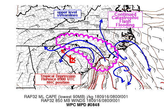
Summary...Heavy rain and catastrophic flash flooding will continue
to affect the central and eastern NC/SC border with an additional
3-6 inches of rain through 15Z. Heavy rain will also begin to
impact portions of the southern Blue Ridge Mountains by late
morning.

Discussion...KLTX reflectivity loops over the past 3-6 hours
showed that a rain band over Brunswick, eastern Columbus and
Bladen counties has not shifted significantly east or west since
03Z. While it has not been continuous, bursts of heavier rain
embedded within the band have been responsible for at least 6
inches of rain near the Wilmington area since 03Z according to
local Wunderground.com stations with rainfall rates fluctuating
between 1-3 in/hr. More recently, another rain band has begun to
focus in northeastern SC affecting Marion, Dillon and Marlboro
counties with KLTX estimated rates of 2-3 in/hr, but without
ground truth to confirm actual rates.

The 09Z advisory from NHC has downgraded Florence to a tropical
depression but the high risk for flash flooding remains. GOES 16
10.3 micron imagery showed an impressive outflow channel on the
eastern side of Florence's circulation across the western
Atlantic, with a 350 mi long band of colder cloud tops tied to the
aforementioned rain band. Strong upper level diffluence continues
across the coastal Carolinas owing to an anticyclone located about
100 miles offshore.

The latest NHC track for Florence takes the center of the
circulation off toward the northwest through 18Z, which when
combined with the onset of daytime heating, should allow CAPE to
slowly increase toward the west through eastern NC/SC, helping
support higher rainfall rates across inland locations (approaching
2-3 in/hr). An additional 3-6 inches of rain is forecast through
15Z for locations generally east of I-85 toward the NC/SC coastal
border. The other effect of Florence tracking toward the west will
be veering 850 mb flow of 50+ kt in western NC allowing a more
perpendicular orientation into the southern Blue Ridge Mountains.
6 hour rainfall into the terrain is expected to range between 1-3
inches through 15Z, but a growing flash flood threat will exist
through the afternoon into the mountains.

Otto

ATTN...WFO...CAE...CHS...GSP...ILM...MHX...RAH...

ATTN...RFC...LMRFC...SERFC...

LAT...LON   36008198 35988131 35838023 35577935 35217832
            34757758 34287730 33827728 32917813 32947928
            34007997 34608097 35028220 35178272 35438292
            35828260
Last Updated: 625 AM EDT Sun Sep 16 2018
|


