| WPC Met Watch |
|
|
Mesoscale Precipitation Discussion: #0858 (2018) |
|
(Issued at 430 PM EDT Mon Sep 17 2018
) |
|
| MPD Selection |
|
|
|
|
|

Mesoscale Precipitation Discussion 0858
NWS Weather Prediction Center College Park MD
430 PM EDT Mon Sep 17 2018

Areas affected...Central North Carolina, Eastern Virginia,
Southern Maryland

Concerning...Heavy rainfall...Flash flooding likely

Valid 172028Z - 180130Z

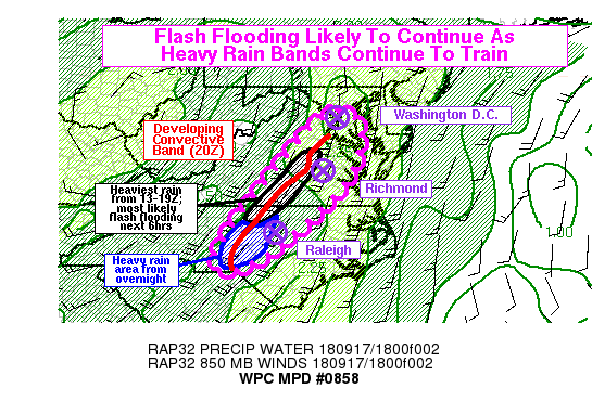
Summary...Heavy rain bands and thunderstorms will continue to push
across portions of central and eastern Virginia, and central North
Carolina into the early evening hours. This should lead to
additional heavy rainfall in areas that have already received
significant rainfall over the past 12-24 hours. This is likely to
lead to a continuation of existing flash flooding, and development
of some new areas of flash flooding.

Discussion...Regional radars from Virginia and North Carolina
showed a broken line of convection becoming more well-defined in
the past hour or two (18-20Z) in an ribbon of enhanced surface
convergence. For example, surface winds in the Triangle region of
NC were out of the SSE (~160-170 degrees), while near Greensboro
they were out of the SW (~210-240 degrees). Strong instability has
been building this afternoon due to a gradual clearing of skies
from the late morning into the early afternoon. RAP analysis
showed MLCAPE in excess of 1500 j/kg from Richmond southward into
central North Carolina, with 500+ j/kg amounts north of Richmond
into the DC Metro Area. These should support more vigorous
convection and indeed there was an increasing amount of lightning
being observed as updraft strength and depth has also increased.
However, at the same time, mid-upper level dry air has been
pushing eastward into the region, with GOES-16 Channel 10 water
vapor imagery showing it reaching the Richmond and Raleigh areas
as of 20Z. Therefore, much of the ongoing convection was likely in
an environment with a reduction in moisture above 500mb. GPS-PW
observations in the drier regions on water vapor imagery was
generally below 1.8 inches, and this could reduce the
precipitation efficiency in the ongoing convection.

However, although extreme tropical rain rates may be less likely,
the environment does continue to support training convection over
areas with saturated or nearly-saturated soils. The convective
band that has developed is aligned favorably with the mean flow
vectors, and should lead to some training patterns over the next
several hours. Over south-central Virginia, the convective band
was centered in the region of heaviest rainfall since 13Z, and in
central North Carolina, the convection was centered in the region
that received the heaviest rainfall overnight. With reduced FFG in
some of these areas, even the 1-2 in/hr rain rates currently
estimated by MRMS and WSR-88D dual pol estimates should be
sufficient to lead to flash flooding -- either by sustaining
ongoing flash flooding or leading to the development of some new
flash flooding. Although the primary focus of this discussion is
on the stronger convective bands and near-term flash flood
potential, it is worth noting that widespread areal and river
flooding is ongoing and will continue from North Carolina into
adjacent portions of South Carolina and Virginia.

Lamers

ATTN...WFO...AKQ...LWX...RAH...RNK...

ATTN...RFC...MARFC...SERFC...

LAT...LON   38957730 38757647 37347670 35827821 34937952
            35078028 36447947 37777841
Last Updated: 430 PM EDT Mon Sep 17 2018
|


