| WPC Met Watch |
|
|
Mesoscale Precipitation Discussion: #0860 (2023) |
|
(Issued at 208 PM EDT Fri Aug 04 2023
) |
|
| MPD Selection |
|
|
|
|
|

Mesoscale Precipitation Discussion 0860
NWS Weather Prediction Center College Park MD
208 PM EDT Fri Aug 04 2023

Areas affected...portions of the southern Missouri Valley

Concerning...Heavy rainfall...Flash flooding likely

Valid 041807Z - 050000Z

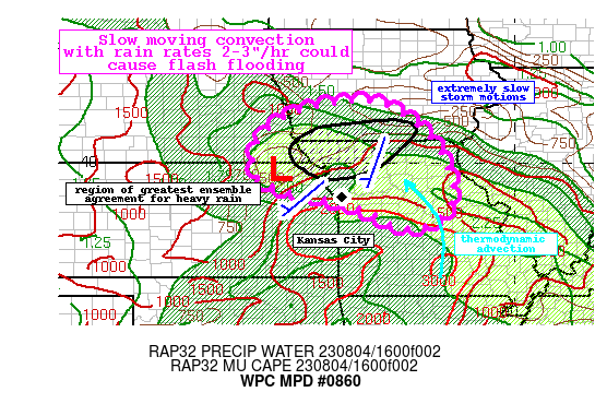
Summary...A wave of low pressure developing across far northeast
KS will drift eastward this afternoon into Missouri. This will
create expanding convection with rain rates reaching 2-3"/hr. Slow
motions of these storms could produce 3-5" of rain and instances
of flash flooding.

Discussion...A convectively enhanced shortwave ejecting out of
Nebraska is helping to amplify a wave of low pressure moving
across northeast Kansas. This is evident in the regional radar
mosaic as an area of circulating reflectivity. This ascent is
impinging into a region of favorable thermodynamics noted by PWs
nearing 2 inches, well above the 90th percentile according to the
SPC sounding climatology, and a corridor of 1000-2000 J/kg MUCAPE.
More concerning is that these thermodynamics are overlapped
efficiently with extremely deep warm cloud depths above 10,000 ft
and low nCAPE, indicating efficient warm rain collision processes
will dominate. This has already resulted in radar-estimated rain
rates exceeding 1"/hr according to KTWX despite reflectivity only
around 35-40 dBZ.

There is still uncertainty into how this will evolve through the
aftn so confidence is modest, but the risk for flash flooding
appears to be increasing. As the low pressure moves slowly
eastward, the enhanced ascent into the favorable thermodyanmics
should drive an expansion and intensification of thunderstorms.
This is reflected in most of the available high-res simulated
reflectivity. While SBCAPE may remain modest due to leading cloud
cover, the impressive theta-e ridge rotating cyclonically around
the low into a modest TROWAL should support enhanced MUCAPE,
resulting in heavy rain rates. The HREF hourly rain-rate
probabilities climb to as high as 40% for 2"/hr, highest in NW MO,
which is well collocated with HRRR 15-min rainfall reaching 1"
(brief 4+"/hr rain rates). 0-6km mean winds are going to remain
quite weak in the vicinity of this low, so although there is some
uncertainty into how widespread convection will become, what does
develop should move extremely slowly at around just 5 kts at
times. This could produce rapid and excessive rainfall
accumulations reaching 3-5", with locally higher amounts noted by
probabilities for 5" reaching 20-40% in both the HREF and
experimental RRFS TL ensemble. Additionally, despite uncertainty
in coverage, the HREF EAS probabilities for 1" reach impressive
values of 20-25%, suggesting higher confidence in the placement of
the heaviest rainfall.

More concerning for the flash flood risk is that these slow
moving, heavy rain producing cells will be occurring atop already
saturated soils. AHPS 14-day rainfall is generally 150-300% of
normal, leading to vulnerable soils noted by high USGS streamflow
anomalies and compromised FFG. The HREF 3-hr FFG exceedance
probabilities reach above 60%, reflective of the likelihood for
instances of flash flooding across these sensitive soils.

Weiss

ATTN...WFO...DMX...DVN...EAX...LSX...OAX...SGF...TOP...

ATTN...RFC...MBRFC...NCRFC...NWC...

LAT...LON   41609429 41479336 40749232 39869176 39089164
            38579196 38339250 38359313 38719376 39059480
            39219561 39329613 39639672 40219685 40779656
            41319572
Last Updated: 208 PM EDT Fri Aug 04 2023
|


