| WPC Met Watch |
|
|
Mesoscale Precipitation Discussion: #0867 (2019) |
|
(Issued at 510 AM EDT Thu Sep 19 2019
) |
|
| MPD Selection |
|
|
|
|
|

Mesoscale Precipitation Discussion 0867
NWS Weather Prediction Center College Park MD
510 AM EDT Thu Sep 19 2019

Areas affected...Southeast TX...Far Western LA

Concerning...Heavy rainfall...Flash flooding likely

Valid 190910Z - 191510Z

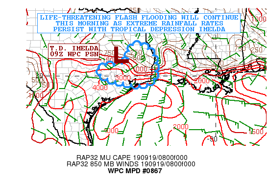
SUMMARY...Life-threatening flash flooding will continue across
areas of southeast Texas this morning as extremely heavy rainfall
persists in association with Tropical Depression Imelda.

DISCUSSION...The center of Tropical Depression Imelda remains
positioned just west of Lufkin, TX and is only very slowly
drifting off to the northwest as of 4AM CDT. Meanwhile, an axis of
extremely heavy showers and thunderstorms continues to impact
areas of southeast Texas, with an emphasis on parts of Liberty,
Chambers, Jefferson and Orange counties where there are currently
Flash Flood Emergencies in effect.

The latest radar imagery shows very well-organized bands of
convection back-building and training across these counties as the
flow around the southern flank of Imelda is highly convergent and
well aligned with a very strong instability gradient. Radar in
conjunction with GOES-16 IR satellite imagery has been showing a
gradual expansion of convection farther off to the west involving
more areas of the northern suburbs of Houston, and including
Montgomery county where very heavy rainfall has been attempting to
become more focused over the last couple of hours.

An examination of the area VWP data suggest the details of the
general west/east axis of stronger low-level forcing/convergence
have changed very little over the past few hours, and the latest
suite of model guidance shows little in the way of change to this
going through the mid-morning hours. This strongly suggests that
the current convective orientation is not likely to change much
over the next several hours. A moderate to strongly unstable
airmass and plenty of deep tropical moisture is expected to remain
in place along and just south of this convergence axis and should
continue to facilitate very strong convection capable of extreme
rainfall rates.

Rainfall rates overnight have been as high as near 5 inches/hr
within the strongest of convective cores, and there have been some
prolific rainfall totals, including a site 3 miles east-northeast
of Hamshire, TX in western Jefferson county where 17.24 inches of
rain was reported in 6 hours through 08Z, and a storm total of
28.11 inches.

Additional rainfall totals through mid-morning of 5 to 10 inches
are expected locally, which will bring some isolated storm totals
for the event to possibly around 35 inches. This is consistent
with the latest HRRR output regarding the additional rainfall
totals. Extreme and life-threatening flash flooding is already
occurring and is expected to continue this morning given the
additional rainfall totals.

Elsewhere, some of the heavy rainfall may again edge into parts of
west-central and southwest LA, but the dominant focus will remain
over southeast TX, with an emphasis Liberty, Chambers, Jefferson
and Orange counties.

Orrison

ATTN...WFO...EWX...HGX...LCH...SHV...

ATTN...RFC...LMRFC...WGRFC...

LAT...LON   31819482 31809435 31589395 31429380 31059356
            30299354 29849361 29509404 29509482 29689571
            29819623 30229688 30579665 30609591 30819528
            31169502 31609505
Last Updated: 510 AM EDT Thu Sep 19 2019
|


