| WPC Met Watch |
|
|
Mesoscale Precipitation Discussion: #0961 (2021) |
|
(Issued at 853 PM EDT Mon Sep 13 2021
) |
|
| MPD Selection |
|
|
|
|
|

Mesoscale Precipitation Discussion 0961
NWS Weather Prediction Center College Park MD
853 PM EDT Mon Sep 13 2021

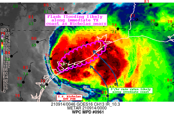
Areas affected...Middle TX Coast

Concerning...Heavy rainfall...Flash flooding likely

Valid 140052Z - 140452Z

Summary...The intense rain bands associated with Nicholas will
gradually move onshore through tonight. Rain rates up to 3"/hr
will become common, especially after 10 PM CDT, which will
increase the likelihood of instances of flash flooding.

Discussion...The center of Nicholas slowly moving north/northeast
will begin to come onshore over the next several hours along the
middle Texas coast. Recent radar imagery from CRP and HGX shows
widespread moderate to locally heavy rainfall associated with the
storm's center beginning to impact the coastal areas with a recent
2.13" hourly report from Port O'Connor, TX.

The favorable orientation of the low level flow and convergence
with the coast will enhance the efficiency of the rain bands as
they pivot along the coastal areas between Port O'Connor to near
Jamaica Beach into tonight. The latest RAP suggests 50+ kt of 850
mb flow becoming perpendicular to the coast after 03Z, which will
help drive higher rain rates. This is also where the last several
runs of the HRRR and the 18Z NAM3km show the greatest potential
for rainfall totals greater than 6" through early tonight and
where the HREF probabilities of exceeding 10-year ARI is highest.
The lack of instability inland will likely keep the highest
rainfall totals initially tied to the immediate coast where the
training/repeating rounds setup, with the threat of heaviest
rainfall moving up the coast through the night as the storm tracks
onshore.

Taylor

ATTN...WFO...CRP...HGX...

ATTN...RFC...WGRFC...NWC...

LAT...LON   29529493 29349473 29049504 28779538 28569605
            28389657 28869636 29179590 29319555 29399526
Last Updated: 853 PM EDT Mon Sep 13 2021
|


