| WPC Met Watch |
|
|
Mesoscale Precipitation Discussion: #0971 (2021) |
|
(Issued at 1235 PM EDT Wed Sep 15 2021
) |
|
| MPD Selection |
|
|
|
|
|

Mesoscale Precipitation Discussion 0971...Corrected
NWS Weather Prediction Center College Park MD
1235 PM EDT Wed Sep 15 2021

Corrected for Flash Flooding Category

Areas affected...Central Gulf Coast

Concerning...Heavy rainfall...Flash flooding likely

Valid 151630Z - 152230Z

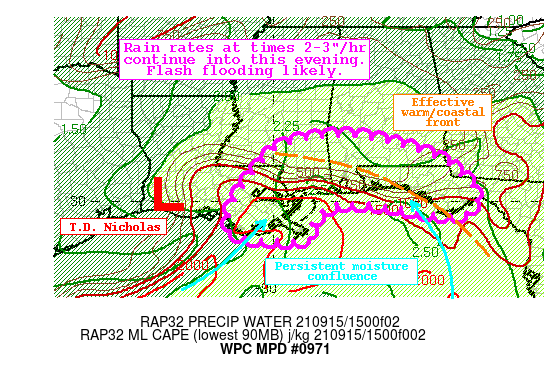
Summary...Tropical Depression Nicholas will continue to drift
slowly eastward, continuing heavy rainfall across the Gulf Coast.
Rainfall rates will at times reach 3"/hr, producing an additional
2-4" of rain with locally higher amounts. Flash flooding is likely.

Discussion...Tropical Depression Nicholas was located at 1500Z
about 30 miles ENE of Lake Charles, LA and was drifting ENE at 5
mph. The center of Nicholas is now well displaced from the heavy
rainfall, which is spread from Vermilion Bay, LA eastward towards
the Forgotten Coast of FL, and northward to around I-20 in MS and
AL. The heaviest rain continues to occur near the coast, south of
an effective warm front and into better instability which is
analyzed by the RAP to be 500-1000 J/kg, highest over the Gulf of
Mexico. This instability is fueling additional convection in an
environment characterized by PWs above 2.5" according to recent
GPS observations, and freezing levels approaching 16,000 ft. These
favorable thermodynamics are producing efficient rain rates which
have recently been estimated by KMOB to be 2-2.5"/hr, and MRMS
3-hr estimated rainfall has been more than 4 inches near
Pascagoula, MS.

The regional radar mosaic and GOES-E IR imagery depicts continuing
bands of inflow rotating onshore within an in-situ warm sector
east of a push of drier air south of Lake Charles, LA and south of
an effective coastal/warm front draped from near Jackson, MS to
Apalachicola, FL. Robust thermodynamics within this warm sector
are driving regeneration of showers and thunderstorms which then
rotate onshore with training rain rates of 2-3"/hr. This is likely
to persist as 850mb inflow east of Nicholas accelerates and
converges from both the S/SW and S/SE. This is reflected by NAEFS
ensemble tables depicting IVT of 2-3 standard deviations above the
climo mean through the evening, before waning early tonight,
suggesting the heaviest rainfall is likely the next 3-6 hours.

The high-res CAMs are in pretty good agreement depicting a narrow
west to east corridor of 2-4" of rainfall with locally much higher
amounts of 6"+. This is where the advection of moisture and
instability most orthogonally intersects the effective coastal
front to drive locally intense ascent, and where the tropical
airmass can most efficiently squeeze out heavy rainfall.
Individual cells will likely remain quick as noted by RAP
850-300mb winds of 20 kts, but anti-parallel propagation vectors
back into the instability suggest backbuilding and training, with
only slow eastward translation of each band.

This area has already received widespread 3-7" of rain the last 24
hours, and NASA SPoRT 40cm soil moisture is above the 95th
percentile. Any additional rainfall will quickly lead to runoff
and flash flooding, and where training of the most intense
rainfall occurs locally significant flash flooding is possible.


Weiss

ATTN...WFO...JAN...LCH...LIX...MOB...TAE...

ATTN...RFC...LMRFC...SERFC...NWC...

LAT...LON   31878798 31818728 31558616 31138507 31008497
            30418427 29968423 29628466 29698564 29928700
            29948787 29908832 29658873 29318893 29068886
            28898917 28908986 28969063 29109122 29519128
            30279095 31508994 31838866
Last Updated: 1235 PM EDT Wed Sep 15 2021
|


