| WPC Met Watch |
|
|
Mesoscale Precipitation Discussion: #1002 (2024) |
|
(Issued at 153 PM EDT Fri Sep 13 2024
) |
|
| MPD Selection |
|
|
|
|
|

Mesoscale Precipitation Discussion 1002
NWS Weather Prediction Center College Park MD
153 PM EDT Fri Sep 13 2024

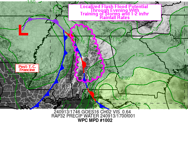
Areas affected...central/northern AL into southern TN

Concerning...Heavy rainfall...Flash flooding possible

Valid 131753Z - 132350Z

SUMMARY...Narrow training axes of heavy rain will support a
localized flash flood threat across central to northern AL into
far southern TN through 00Z. Rainfall rates of 1-2 in/hr are
expected.

DISCUSSION...17Z regional radar imagery showed a broken/narrow
axis of showers/thunderstorms extending from southern TN into
western AL, located along an elevated convergence axis, out ahead
of a cold front associated with Post-Tropical Cyclone Francine.
The convergence axis has been slowly moving east over the past few
hours but rainfall intensity has been increasing following trends
in instability. The 17Z SPC mesoanalysis indicated MLCAPE of 500
to 1500+ (locally) extending from Middle TN into much of AL with
little to no CIN. However, visible imagery showed stratus/overcast
conditions across eastern to northeastern AL where low level
convective inhibition is likely to keep convection at bay in the
short term. The 12Z BMX sounding and recent GPS data across AL
showed precipitable water values of 1.3 to 1.7 inches (...and
higher across far southeastern AL), but with a notable dry layer
aloft, extending as far down as just below 700 mb.

Continued daytime heating, especially where current breaks in
cloud cover exist, will support a continued expansion of
instability across central to northern AL with greater coverage of
1500+ J/kg anticipated by 21Z. Mean southerly steering flow will
allow for training of heavy rain at times along the roughly
north-south oriented convergence axis slowly moving east and other
smaller scale axes of convergence to the east of the existing line
over western AL. While a pronounced layer of dry air noted in the
mid-upper levels may deter broader coverage of heavy rainfall
development, at least localized areas of training with 1-2 in/hr
rain rates will be possible. These rates may overlap with recent
pockets of heavy rain which fell across the region over the past
48 hours and/or sensitive urban areas to produce possible, but
likely remaining localized, areas of flash flooding through 00Z.

Otto

ATTN...WFO...BMX...HUN...MEG...MOB...OHX...

ATTN...RFC...LMRFC...SERFC...NWC...

LAT...LON   35748802 35688766 35318702 33948656 32418612
            31818693 31758758 32048800 33418787 34628818
            35288837 35568829
Download in GIS format: Shapefile
| KML
Last Updated: 153 PM EDT Fri Sep 13 2024
|


