| WPC Met Watch |
|
|
Mesoscale Precipitation Discussion: #1005 (2024) |
|
(Issued at 755 PM EDT Fri Sep 13 2024
) |
|
| MPD Selection |
|
|
|
|
|

Mesoscale Precipitation Discussion 1005
NWS Weather Prediction Center College Park MD
755 PM EDT Fri Sep 13 2024

Areas affected...portions of northeastern Mississippi, middle
Tennessee, and Alabama

Concerning...Heavy rainfall...Flash flooding likely

Valid 132354Z - 140554Z

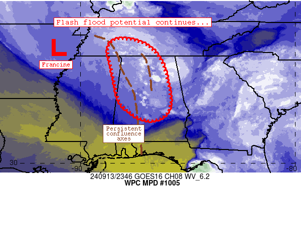
Summary...Flash flood potential will continue through the early
overnight hours as bands of convection train/repeat across areas
that have experienced 1-3 inch rainfall totals over the past 6
hours.

Discussion...Radar mosaic imagery depicts a couple of focused
bands of convective activity with extensive training/repeating -
one across far northeastern Mississippi near Booneville/Corinth
and another, more extensive band from near Selma to near Decatur.
Within both of these axes, 1-3 inches of rain have fallen in the
past 6 hours, and instances of flooding have been reported.  The
bands are collocated with persistent low-level confluence along
the eastern periphery of Francine.  Low-level advection and
remaining boundary layer heat from earlier insolation has
maintained an axis of ~1000 J/kg SBCAPE near the storms, which has
enabled their persistence over the past several hours.  1.7-1.9
inch PW values are also aiding in efficiency of rain rates beneath
storms as well.

The ongoing scenario is expected to change little, with continued
areas of occasional 1 inch/hr rain rates to materialize over
similar areas that received heavy rainfall earlier.  Modest
boundary layer cooling/stabilization could result in a few areas
of weakening thunderstorm cores, although models suggest that
persistent low-level convergence will maintain shower/thunderstorm
activity through the early overnight hours - especially across
Alabama.  Flash flood potential will continue as another 1-3 inch
rainfall totals could materialize across the discussion area
through 06Z.

Cook

ATTN...WFO...BMX...HUN...JAN...MEG...MOB...OHX...

ATTN...RFC...LMRFC...SERFC...NWC...

LAT...LON   35798823 35558703 34858631 33828597 32698584
            32128624 32048704 32758811 34208850 35368871
Download in GIS format: Shapefile
| KML
Last Updated: 755 PM EDT Fri Sep 13 2024
|


