| WPC Met Watch |
|
|
Mesoscale Precipitation Discussion: #1015 (2023) |
|
(Issued at 1214 AM EDT Fri Sep 01 2023
) |
|
| MPD Selection |
|
|
|
|
|

Mesoscale Precipitation Discussion 1015
NWS Weather Prediction Center College Park MD
1214 AM EDT Fri Sep 01 2023

Areas affected...southern to northwestern AZ into southwestern UT
and southeastern NV

Concerning...Heavy rainfall...Flash flooding possible

Valid 010409Z - 010915Z

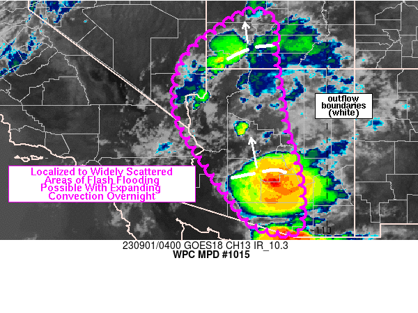
Summary...Areas of localized to widely scattered flash flooding
will be possible across southern to northwestern AZ into
southeastern NV and southwestern UT overnight. Thunderstorms will
carry the potential for rainfall rates of 1-2 inches in 30-60
minutes.

Discussion...Several areas of thunderstorms were observed across
the Desert Southwest as of 0345Z via infrared satellite and
regional radar imagery. A mid to upper level ridge centered over
east-central NM and troughing along/offshore of the West Coast was
allowing for southerly flow through AZ along with steadily
increasing moisture observed since 12Z Thursday. Moisture
anomalies were greatest over the Colorado River Valley with 22Z
and 00Z soundings at 1Y7 and VEF (respectively) showing
precipitable water values well above the 90th percentile via the
SPC sounding climatology page. 00Z soundings from TUS, PSR, FGZ
and VEF also showed up to 1000 J/kg MLCAPE but with significant
dry layers in the 0-10 kft AGL layer, supporting outflow dominant
storms/clusters. One thunderstorm cluster over southern AZ was
associated with a northward moving outflow boundary that crossed
through the Phoenix metro around 0330Z and another translating
north from southern UT.

Despite cooling surface temperatures into the night, fairly steep
mid-level lapse rates and continued advection of low to mid-level
moisture will likely maintain sufficient instability overnight to
support additional rounds of nocturnal convection. Expectations
are for thunderstorms to expand northward from the ongoing cluster
over Maricopa and Pinal counties, with localized cell development
in advance of the outflow boundary. Repeating rounds of
thunderstorms will be possible despite a progressive movement
toward the north. For locations farther north, relatively stronger
700 mb flow near 20 kt will allow for repeating and brief training
of thunderstorms from the southern CA/NV border toward the
northeast. T

he environment will be supportive of 1-2 inches of rain in 30-60
minutes with stronger cores and/or any training that is able to
materialize. A few areas of flash flooding will be possible as a
result, especially if overlap of heavy rain occurs with burn scars
or low water crossings/creeks/normally dry washes.

Otto

ATTN...WFO...FGZ...PSR...SLC...TWC...VEF...

ATTN...RFC...CBRFC...CNRFC...NWC...

LAT...LON   38881259 38611182 37401178 36171160 34891140
            34061113 33561098 32971090 32321086 31861089
            31521101 31511135 31771243 32491306 33591388
            35461498 37221478 38311360
Last Updated: 1214 AM EDT Fri Sep 01 2023
|


