| WPC Met Watch |
|
|
Mesoscale Precipitation Discussion: #1046 (2023) |
|
(Issued at 309 PM EDT Sat Sep 09 2023
) |
|
| MPD Selection |
|
|
|
|
|

Mesoscale Precipitation Discussion 1046
NWS Weather Prediction Center College Park MD
309 PM EDT Sat Sep 09 2023

Areas affected...Virginia, Maryland

Concerning...Heavy rainfall...Flash flooding possible

Valid 091908Z - 100100Z

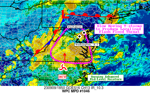
Summary...Slow moving thunderstorms developing across the
Mid-Atlantic states will persist into this evening. Rainfall rates
of 1-2"/hr are likely, which through slow motions could produce
2-4" of rainfall. Flash flooding is possible, most likely in urban
areas.

Discussion...The regional radar mosaic this afternoon indicates
multiple clusters of thunderstorms lifting across NC/VA/MD. These
storms are moving northward within a region of robust
thermodynamics characterized by PWs of 1.5-1.7 inches and SBCAPE
of 2500-3500 J/kg. A weak, but convectively enhanced shortwave/MCV
is noted in WV imagery lifting northward into VA, while an
anomalous mid-level trough centered over the TN VLY shifts slowly
eastward driving modest height falls across the region. A weak
upper jet streak pivoting northward downstream of this trough axis
is enhancing ascent as well through its diffluent LFQ. With nearly
unidirectional flow from the sfc-200mb noted in morning U/A
soundings, pronounced moist advection will persist, and it is
likely even more widespread thunderstorms will impact the region
through this evening.

Rainfall rates already today have been estimated to be 2.5-3"/hr
from KLWX, which has resulted in more than 2.5 inches of rainfall
at a few mesonet sites near Washington, D.C. Unfortunately, the
high-res guidance is struggling with the activity across MD this
aftn, so confidence is slightly below average. It is likely that
the pool of impressive SBCAPE around the Chesapeake Bay and
extending towards I-95, along with locally higher PWs, are not
being sampled by the high-res guidance, resulting in the lack of
activity in this area. Radar trends and the SPC RAP analysis
suggest these storms will continue to re-fire along the intense
instability gradient, with Corfidi vectors likely collapsing to
near zero as storms build back to the S/SE into the higher
instability. This may persist until the robust convection lifting
out of NC/VA, which is reflected by the high-res simulated radar,
lifts north by this evening. Rainfall rates within any of these
thunderstorms could produce 3"/hr rates (HRRR 15-min rainfall as
high as 0.75"), which through training and/or slow storm motions
could result in 2-4" of rainfall. Although the HREF and RRFS
probabilities for more than 3" are limited, the ingredients and
environment suggest some locations across MD/N VA could approach
5" of rainfall by this evening.

14-day rainfall has been well below normal according to AHPS,
which has led to FFG as high as 4"/3hrs across most of the area.
While exceedance of these probabilities is less than 5% according
to the HREF, which again is struggling, it is possible that rapid
runoff and flash flood instances will occur where the most intense
training or multiple rounds of heavy rainfall occur. While flash
flooding is possible anywhere across this area this evening, it
will be most likely should training occur in the less permeable
urban areas.


Weiss/Snell

ATTN...WFO...AKQ...LWX...RAH...RNK...

ATTN...RFC...MARFC...SERFC...NWC...

LAT...LON   39637803 39597682 38707639 37757612 36827591
            36497616 36437699 36497799 36737920 37357967
            38157925 39087859
Last Updated: 309 PM EDT Sat Sep 09 2023
|


