| WPC Met Watch |
|
|
Mesoscale Precipitation Discussion: #1057 (2024) |
|
(Issued at 414 PM EDT Wed Sep 25 2024
) |
|
| MPD Selection |
|
|
|
|
|

Mesoscale Precipitation Discussion 1057
NWS Weather Prediction Center College Park MD
414 PM EDT Wed Sep 25 2024

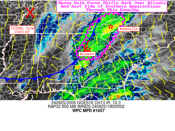
Areas affected...North Georgia and the Southern Appalachians

Concerning...Heavy rainfall...Flash flooding likely

Valid 252013Z - 260200Z

SUMMARY...Training thunderstorms will continue to lift over the
Atlanta Metro area rest of this afternoon and over the eastern
side of the southern Appalachians through tonight. Flash flooding
is likely, particularly in Appalachian terrain, through this
evening before becoming considerable to catastrophic overnight.

DISCUSSION...Convergence of the tropical plume of moisture ahead
of Helene and a cold front over southern Alabama has allowed a
particularly heavy line of slow-moving and training thunderstorms
to develop over southeast AL into western GA. This northward shift
in moisture is driven by an upper low centered over far western
KY. Recent rainfall estimates of 2 to 3" per hour are from KFFC
and KMXX over eastern AL/western GA. The heaviest rain thus far
has stayed south of the Atlanta metro and outflow is seen on KFFC
which indicates the main threat for now to be avoiding that
particular area.

However, the tropical moisture plume with PW of 2 to 2.25" will
shift up the AL/GA border rest of the afternoon, pushing moisture
and instability back over the Atlanta metro and then up the
eastern side of the southern Appalachians through this evening.
Terrain enhanced rainfall there will quickly fill in a gap of
rainfall over the past day that in western NC (surrounding
Asheville). Rates of 2"/hr is likely by this evening which would
exceed the FFG of 1.5-2"/hr. Flash flooding is likely through 02Z.
The 18Z HRRR depiction of 2-4" in terrain over western NC and
northeast GA is reasonable, but around 1" additional seems low for
north-central GA and the Atlanta metro with a few additional
inches possible.

The much greater threat for flooding area-wide is expected to be
later tonight as even stronger southeasterly flow associated with
the approach of Helene pushes ever greater moisture into the same
eastern slopes of the southern Appalachians with potentially
catastrophic flash flooding overnight.

Jackson

ATTN...WFO...FFC...GSP...MRX...RNK...

ATTN...RFC...LMRFC...OHRFC...SERFC...NWC...

LAT...LON   36478281 36268158 34908229 33878304 33158365
            33158508 33548517 34468443 35388418
Download in GIS format: Shapefile
| KML
Last Updated: 414 PM EDT Wed Sep 25 2024
|


