| WPC Met Watch |
|
|
Mesoscale Precipitation Discussion: #1059 (2023) |
|
(Issued at 558 PM EDT Mon Sep 11 2023
) |
|
| MPD Selection |
|
|
|
|
|

Mesoscale Precipitation Discussion 1059
NWS Weather Prediction Center College Park MD
558 PM EDT Mon Sep 11 2023

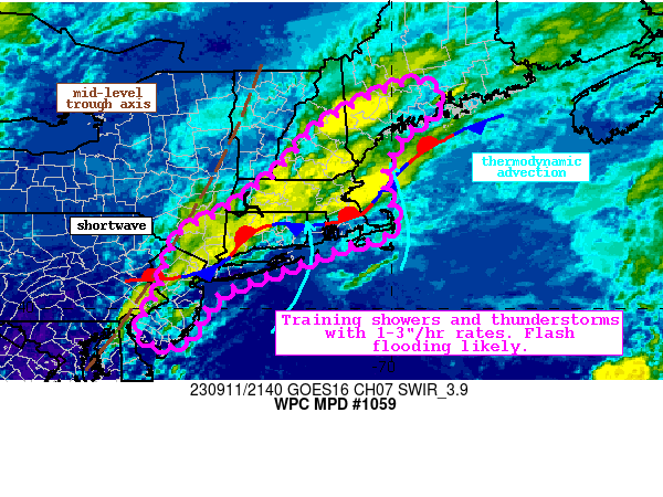
Areas affected...Coastal Mid-Atlantic states through eastern New
England

Concerning...Heavy rainfall...Flash flooding likely

Valid 112200Z - 120400Z

Summary...Showers and thunderstorms will continue to expand across
the Northeast through early tonight. Rainfall rates may reach
3"/hr at times, which through training could produce 2-4" of rain
with locally higher amounts. Flash flooding is likely.

Discussion...The regional radar mosaic early this evening shows
widespread showers and thunderstorms organizing along a stationary
front arced from the Mid-Atlantic into New England. This surface
front is providing strong low-level convergence, aiding modest
height falls downstream of a mid-level trough axis and LFQ jet
level diffluence to produce robust deep layer ascent. This lift is
occurring into a region of extremely favorable thermodynamics
noted by PWs measured via GPS of 1.7-1.9 inches, well above the
90th percentile at CHH/GYX according to the SPC sounding
climatology, and a ribbon of SBCAPE of 1000-1500 J/kg. The special
18Z U/A soundings at OKX and GYX featured deep warm cloud depths
with near most-adiabatic lapse rates throughout, suggesting
efficient warm rain processes are dominating, and this is
reflected by radar-estimated rain rates above 3"/hr according to
KBOX leading to impressive FLASH responses.

During the past hour or two, the radar signatures have become more
organized and intense, likely in response to the building
instability within clearing sky conditions. Instability is progged
to continue to climb, albeit modestly, for a few more hours,
before waning/exhausting, which will combine with even stronger
ascent as the upper jet intensifies and the primary trough axis
advects east, to produce widespread heavy rain producing
convection. This is reflected by most high-res simulated
reflectivity, and the HREF hourly-rain rate probabilities for
2"/hr and 3"/hr reach 30-40%, and 5-15%, respectively.
Additionally, the HRRR indicates that some areas may receive
0.75-1"/15 min (brief 4"/hr rain rates). Although mean 0-6km winds
will remain rather progressive at 20-25 kts to the northeast,
aligned Corfidi vectors of 10-15 kts suggest training is likely,
especially where regeneration occurs as parcels isentropically
ascend the stationary front. Within bands of the most intense
training, rainfall could reach 2-4" with HREF exceedance
probabilities for 5" even rising to 20% in a few areas.

This region has quite wet recently noted by AHPS 7-day rainfall
departures that are 200-300% of normal in many areas. This has led
to 40cm soil moisture that is at or above the 98th percentile in
many locations, compromising FFG to as low as 1.5-2"/3hrs. The
HREF FFG exceedance probabilities across eastern New England are
progged to reach 30-40%, suggesting this is the region of greatest
probability for instances of flash flooding. However, these
intense rain rates could cause local runoff and flash flood issues
anywhere training can occur, or atop the less permeable urban
areas.

Weiss

ATTN...WFO...ALY...BGM...BOX...GYX...OKX...PHI...

ATTN...RFC...MARFC...NERFC...NWC...

LAT...LON   44766955 44496895 44276903 44026931 43666983
            42857018 42277013 41946992 41667000 41477033
            41377093 41037179 40677275 40477336 40187380
            39947401 39637416 39297445 39217489 39277512
            39427530 39737525 40187497 40527484 40997470
            41527449 41827398 42097343 42867240 43797156
            44287075
Last Updated: 558 PM EDT Mon Sep 11 2023
|


