| WPC Met Watch |
|
|
Mesoscale Precipitation Discussion: #1081 (2024) |
|
(Issued at 143 PM EDT Sun Sep 29 2024
) |
|
| MPD Selection |
|
|
|
|
|

Mesoscale Precipitation Discussion 1081
NWS Weather Prediction Center College Park MD
143 PM EDT Sun Sep 29 2024

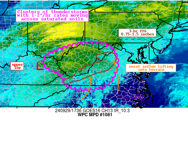
Areas affected...Central Appalachians

Concerning...Heavy rainfall...Flash flooding possible

Valid 291743Z - 292300Z

Summary...Clusters of showers and thunderstorms will develop and
lift northward through the afternoon. Rainfall rates of 1-2"/hr
within these cells could repeat to produce 1-3" of rainfall. This
occurring atop pre-saturated soils may result in instances of
flash flooding.

Discussion...The regional radar mosaic this afternoon shows
widespread light showers across the Ohio Valley and Mid-Atlantic,
with embedded convective elements beginning to blossom across
VA/WV. This convective activity is deepening in response to a
ribbon of 500-1000 J/kg of SBCAPE which has expanded across the
area south of a wedge front and north of a stationary front. PWs
of 1.5-1.7 inches, or above the 90th percentile according to the
SPC sounding climatology, are contributing to intensifying
thermodynamics to support this convective activity. Forcing for
ascent is additionally intensifying downstream of an upper low
over KY, with SE 850mb winds of 10-15 kts lifting isentropically
and orographically to combine with upper divergence and
diffluence.

As the aftn progresses, the high-res CAMs are in good agreement
that convective coverage will expand in response to the increasing
ascent within the favorable thermodynamics. Although coverage will
likely remain scattered, aligned Corfidi vectors and mean 0-6km
winds suggests repeating rounds of convection are likely in many
areas. These thunderstorms will likely intensify through the aftn
as well to produce rainfall rates for which both the HREF and REFS
neighborhood probabilities indicate have a 40-50% of exceeding
1"/hr, and 15-min HRRR fields indicate an isolated potential for
2"/hr rates. Despite the progressive and scattered nature of these
cells, multiple rounds lifting N/NW into the area could produce
rainfall amounts of 1-3" in some areas.

This region has been saturated recently, noted by 7-day rainfall
departures from AHPS that area in most areas 300-600% of normal.
This has led to fully saturated soils and compromised FFG that is
as low as 0.75-1.5" in 3 hours. The HREF FFG exceedance
probabilities peak as high as 70% by this evening, highest in the
vicinity of Shenandoah NP and into the Allegheny Mountains.
However, flash flooding will be possible anywhere the most intense
rates repeat atop the saturated soils or across vulnerable terrain.


Weiss

ATTN...WFO...AKQ...ILN...JKL...LWX...MRX...PBZ...RLX...RNK...

ATTN...RFC...LMRFC...MARFC...OHRFC...SERFC...NWC...

LAT...LON   39688000 39577916 39057841 38017819 36697888
            36398001 36428122 36648186 37068204 37588244
            37798310 38078343 38628344 39078263 39468140
Download in GIS format: Shapefile
| KML
Last Updated: 143 PM EDT Sun Sep 29 2024
|


