| WPC Met Watch |
|
|
Mesoscale Precipitation Discussion: #1111 (2023) |
|
(Issued at 505 AM EDT Fri Sep 29 2023
) |
|
| MPD Selection |
|
|
|
|
|

Mesoscale Precipitation Discussion 1111
NWS Weather Prediction Center College Park MD
505 AM EDT Fri Sep 29 2023

Areas affected...Far Eastern PA...Much of NJ...Southeast NY and
Long Island...Western CT

Concerning...Heavy rainfall...Flash flooding likely

Valid 290905Z - 291505Z

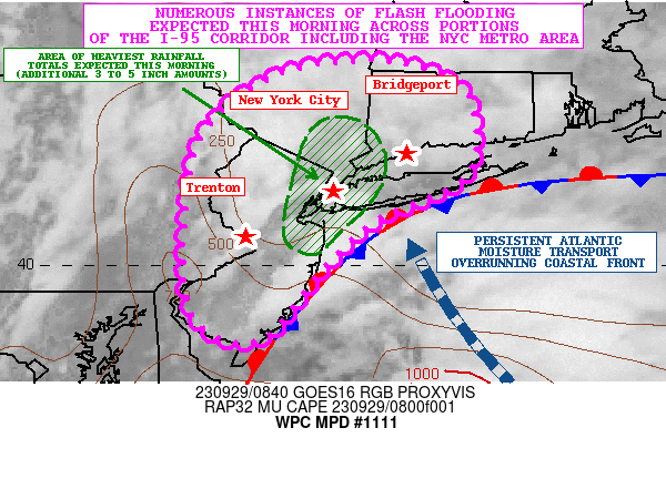
SUMMARY...Heavy rainfall and numerous instances of flash flooding
can be expected this morning across portions of the I-95 corridor
from central and northern NJ through far southeast NY and into
western CT. This will include the New York City metropolitan area
where locally significant runoff problems and urban flooding
generally appears likely.

DISCUSSION...Heavy shower and occasional thunderstorm activity
continues to generally expand in coverage along the I-95 corridor
from areas of central and northern NJ up through far southeast NY
and southwest CT. Recent radar trends have actually shown some
uptick in convection also across areas farther down to the
southwest involving southern NJ near the Atlantic City area, and
into a little bit of eastern PA.

The convection continues to develop and organize in response to a
upper-level trough approaching from the OH Valley and interacting
with a strengthening coastal front just offshore of the northern
Mid-Atlantic and southern New England coasts. A well-defined
low-level southeasterly fetch of moisture and warm air advection
continues to overrun this boundary, and this is favoring broad
isentropic ascent and areas of upright convection given a gradual
increase in instability in close proximity to the front. In fact,
the latest RAP analysis shows MUCAPE values of as much as 500 to
1000 J/kg, with some of the greatest positive 3-hour CAPE
differentials occurring over eastern PA and into NJ given arrival
of slightly steeper mid-level lapse rates with the upper trough.

The latest experimental CIRA-LVT data shows a notable surge of
southeasterly moisture transport in the SFC/850 mb layer advancing
toward coastal areas of central and northern NJ, far southeast NY
and Long Island which should help yield greater rainfall
efficiency and heavier rainfall rates closer to 12Z (8AM EDT) and
extending through 15Z (11AM EDT) with convection likely becoming
more concentrated and focused along the I-95 urban corridor.

Rainfall rates should easily reach into the 1 to 2 inch/hour range
this morning with the stronger convective cores, and the 00Z/06Z
HREF guidance favors this along with additional rainfall totals
locally of 3 to 5 inches by late this morning.

The additional heavy rainfall is likely to result in numerous
instances of flash flooding this morning, and this will include
the I-95 corridor from generally central and northern NJ through
far southeast NY, and into western CT. This will include the
entire New York City metropolitan area where locally significant
runoff problems and urban flooding appears likely.

Orrison

ATTN...WFO...ALY...BGM...BOX...OKX...PHI...

ATTN...RFC...MARFC...NERFC...NWC...

LAT...LON   42147334 41907260 41527241 40917252 40487343
            39957401 39227464 39327525 39837545 40967540
            41597509 42047434
Last Updated: 505 AM EDT Fri Sep 29 2023
|


