| WPC Met Watch |
|
|
Mesoscale Precipitation Discussion: #1112 (2023) |
|
(Issued at 1116 AM EDT Fri Sep 29 2023
) |
|
| MPD Selection |
|
|
|
|
|

Mesoscale Precipitation Discussion 1112
NWS Weather Prediction Center College Park MD
1116 AM EDT Fri Sep 29 2023

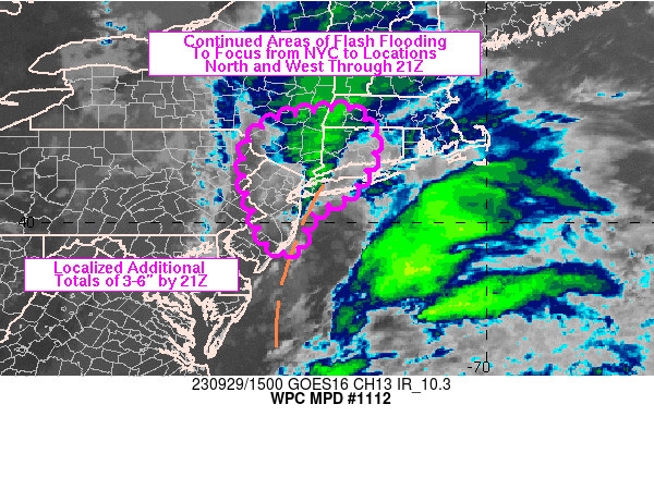
Areas affected...far eastern PA into NJ, southern NY/Long Island,
CT and western MA

Concerning...Heavy rainfall...Flash flooding likely

Valid 291515Z - 292045Z

SUMMARY...Flash flooding will remain likely across the tri-state
region over the next few hours, some of which could be significant
to major. Rainfall rates of 1-3 in/hr and additional totals of 3-6
inches prior to 21Z should be expected, leading to a very
dangerous situation if these totals overlap with 3-6 inches of
rain which has already fallen over NYC.

DISCUSSION...1445Z regional radar imagery continued to show
widespread moderate to heavy rain across the NYC metro into
southern NY/western CT/western MA. The highest rainfall rates were
located just north of NYC into far western CT, along a low level
convergence axis forced by a mesoscale circulation over NYC.
Wunderground and NYC Mesonet/NYC Micronet gauge data has shown 3-6
inches of rain has fallen across the Five Boroughs with rainfall
rates peaking in the 2-3 in/hr range over Brooklyn around 12Z,
resulting in numerous flash flood impacts across the region. While
lightning observations have been largely absent, a few embedded
thunderstorms have been observed where elevated instability of a
few hundred J/kg was present, rooted near the 850 mb level via the
12Z OKX sounding. Precipitable water values were near 1.6 inches,
just above the 90th percentile for late September but despite the
somewhat modest moisture, forcing for ascent was strong...owing to
low level overrunning of an inverted surface trough which extended
northward from the northern Mid-Atlantic coast into far western
Long Island at 14Z. Low level winds centered near 850 mb were
averaging 20-30 kt from the SE, supporting multiple rounds of
heavy rain with recent redevelopment of heavier rain along and
offshore of Manmouth and Ocean counties in eastern NJ.

Pivoting of the 20-30 kt low level axis of winds to the north of
an 850 mb circulation centered over southern NJ is expected to
support the refocusing of heavy rain into portions of
central/northern NJ while southeasterly flow maintains areas of
heavy rain into southern NY and portions of western CT/MA, where
terrain influences will augment rainfall intensities. The
potential for 1-3 in/hr rates will remain with the higher end of
that range more likely over far eastern PA into NJ where
increasing instability into the early afternoon is expected with
continued low level moisture advection, allowing for MUCAPE values
in the vicinity of 500 J/kg. Flash flooding is likely to continue
across the region, with areas of major flash flooding likely where
overlap of additional heavy rain occurs with areas of ongoing
flash flooding with an additional totals of 3-6 inches expected in
some locations.

Otto

ATTN...WFO...ALY...BGM...BOX...OKX...PHI...

ATTN...RFC...MARFC...NERFC...NWC...

LAT...LON   42417343 42417306 42347274 42067249 41767242
            41367244 40607296 40187373 39397409 39567471
            40207496 40927517 41607515 42127467 42287411
Last Updated: 1116 AM EDT Fri Sep 29 2023
|


