| WPC Met Watch |
|
|
Mesoscale Precipitation Discussion: #1113 (2023) |
|
(Issued at 405 PM EDT Fri Sep 29 2023
) |
|
| MPD Selection |
|
|
|
|
|

Mesoscale Precipitation Discussion 1113
NWS Weather Prediction Center College Park MD
405 PM EDT Fri Sep 29 2023

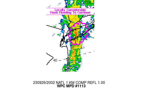
Areas affected...western/central Long Island

Concerning...Heavy rainfall...Flash flooding likely

Valid 291959Z - 292230Z

SUMMARY...Flash flooding to continue with locally
considerable/life threatening flash flooding for portions of
western/central Long Island for another couple of hours. Rainfall
rates of 1-2 in/hr will be likely, but stalling of a mesoscale
axis of heavy rain could support higher rates.

DISCUSSION...Local radar imagery from OKX and TJFK has shown a
slow moving axis of heavy rain slowly tracking east across Nassau
County over the past hour, with hourly rainfall totals of 1-2
inches along with 5-8 inches of rain reported since midnight in
the Lynbrook/Rockville Center vicinity via observations from the
Wunderground network. TJFK showed an apparent mesolow located 7
miles SSE of Long Beach, moving east around 5 kt, with an axis of
enhanced convergence just above the surface extending NNE across
Long Island, supporting heavy rain along it.

Short term model guidance is mixed with the evolution over the
next few hours, but conceptually, as the mesolow continues to move
east, some low level veering of flow ahead of the low is expected
which should act to locally increase elevated instability into
central Long Island, potentially allowing a boost in rainfall
intensity. At its current pace, the low level convergence axis
will be responsible for producing 2-4 inches in about 2 hours
time, but if the axis were to stall or slow,
significant/life-threatening flash flood impacts could result at
the surface with short term totals in excess of 4 inches. Current
thinking is that short term redevelopment of heavy rain
immediately west of the ongoing axis of heavy rain is unlikely.

Otto

ATTN...WFO...OKX...

ATTN...RFC...NERFC...NWC...

LAT...LON   41057311 40967294 40657297 40457335 40517370
            40967353
Last Updated: 405 PM EDT Fri Sep 29 2023
|


