| WPC Met Watch |
|
|
Mesoscale Precipitation Discussion: #1114 (2023) |
|
(Issued at 555 PM EDT Fri Sep 29 2023
) |
|
| MPD Selection |
|
|
|
|
|

Mesoscale Precipitation Discussion 1114
NWS Weather Prediction Center College Park MD
555 PM EDT Fri Sep 29 2023

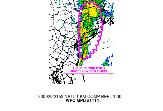
Areas affected...Long Island into southern New England

Concerning...Heavy rainfall...Flash flooding likely

Valid 292152Z - 300345Z

SUMMARY...Flash flooding will be likely to continue for Long
Island into portions of southern New England over the next couple
of hours, but the threat might begin to wane by 03Z. Rainfall
rates of 1-2 in/hr, locally higher, are expected to contribute to
additional rainfall totals of 2 to 4+ inches.

DISCUSSION...2115Z radar imagery showed a slow moving axis of
heavy rain extending from just east of NJ, NNE across west-central
Long Island into western CT. The highest observed rainfall rates
have been over western Long Island with 1-2 in/hr observed working
within weak instability of a couple hundred J/kg MUCAPE. Farther
north into CT, while rates are lower than Long Island, persistent
heavy rain with rates between 0.3 and 0.6 in/hr, locally higher,
has been ongoing for the past 3-4 hours. A low level axis of
convergence, focusing the highest rainfall intensity over Long
Island, had been slowly translating eastward around 5 kt, but
recent trends in radar showed an increase in forward speed closer
to 10 kt over the past hour. Mesoscale circulations embedded along
the convergence axis have supported brief line orientation with
the mean steering flow from the southwest and increased short term
training with rain rates locally above 1.5 in/hr.

As a closed upper level low over east-central PA and related
diffluent flow continue to shift east over the next 3-6 hours,
southeasterly flow focused in the 1-2 km AGL layer of 20-30 kt
(KOKX VAD Wind profile) will maintain an axis of moisture
transport and isentropic ascent across an offshore surface trough
with areas of heavy rain continuing from Long Island into CT, MA
and possibly RI, with the axis of heaviest rain shifting from west
to east. While weak instability may begin to move into areas of
southern New England after 00Z, the potential for focused, slow
moving ascent appears as if it will wane through time. While the
threat for higher end flash flooding may be decreasing into the
early overnight, continued flash flooding is expected for portions
of Long Island into southern New England with an additional 2-4
inches of rain expected over the next 6 hours.

Otto

ATTN...WFO...ALY...BOX...GYX...OKX...

ATTN...RFC...NERFC...NWC...

LAT...LON   42967213 42847175 42537140 41307166 40157273
            39827378 41457334 42627284
Last Updated: 555 PM EDT Fri Sep 29 2023
|


