| WPC Met Watch |
|
|
Mesoscale Precipitation Discussion: #1129 (2023) |
|
(Issued at 535 AM EDT Wed Oct 04 2023
) |
|
| MPD Selection |
|
|
|
|
|

Mesoscale Precipitation Discussion 1129
NWS Weather Prediction Center College Park MD
535 AM EDT Wed Oct 04 2023

Areas affected...Southeast TX

Concerning...Heavy rainfall...Flash flooding likely

Valid 040935Z - 041535Z

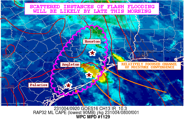
SUMMARY...Showers and thunderstorms will be increasing in coverage
this morning. Locally extreme rainfall rates can be expected, and
there will be an increasing likelihood for at least scattered
instances of flash flooding. This will be aided by a combination
of urban sensitivities and relatively wet antecedent conditions.

DISCUSSION...There is a relatively focused channel of stronger
moisture convergence and corresponding axis of greater instability
becoming situated over portions of the southeast TX coastal plain
as low-level southeast flow persists off the anomalously warm Gulf
of Mexico. In fact, the latest CIRA-LVT data is showing a ribbon
of stronger moisture transport showing up in the 850/700 mb layer
rounding the southern and western periphery of the low to
mid-level ridge over the central Gulf Coast states which is taking
aim on the middle TX coast.

The latest RAP analysis shows a nose of MLCAPE values reaching
1500 to 2000+ J/kg, and the latest Blended NESDIS-TPW data shows
PWs solidly running up into the 2.0 to 2.25 inch range. This
pooling of moisture and instability early this morning will set
the stage for developing and expanding clusters of showers and
thunderstorms that will be capable of producing extreme rainfall
rates that may reach 2 to 3 inches/hour. Favorably deep warm cloud
layer profiles connected to the high PW environment will support
very high rainfall efficiency and these extreme rates.

Increasingly diffluent flow aloft and stronger low-level forcing
will be drivers of a more concentrated convective threat across
southeast TX and especially along and just inland of the coast
from the Houston metropolitan area down through Angleton and
toward Palacios.

The 00Z HREF guidance supports relatively small-scale clusters and
linear bands of convection that will be capable of backbuilding
and locally training over the same area. The result is expected to
be very heavy rainfall totals which by late morning may reach as
high as 3 to 6 inches.

Some areas saw very heavy rainfall yesterday, and especially
around the Angleton area where some 4 to 6+ inch rainfall amounts
occurred. This has led to locally wet/sensitive soil conditions.
This coupled with concerns of extreme rainfall rates this morning
getting into the more sensitive urban environments suggests an
increasing flash flood threat, and at least scattered instances of
flash flooding will be likely by late this morning.

Orrison

ATTN...WFO...CRP...EWX...HGX...

ATTN...RFC...WGRFC...NWC...

LAT...LON   30889507 30309485 29449496 28909529 28579584
            28459643 28669676 28999684 29599666 30249626
            30849569
Last Updated: 535 AM EDT Wed Oct 04 2023
|


