| WPC Met Watch |
|
|
Mesoscale Precipitation Discussion: #1136 (2021) |
|
(Issued at 1247 PM EST Thu Nov 25 2021
) |
|
| MPD Selection |
|
|
|
|
|

Mesoscale Precipitation Discussion 1136
NWS Weather Prediction Center College Park MD
1247 PM EST Thu Nov 25 2021

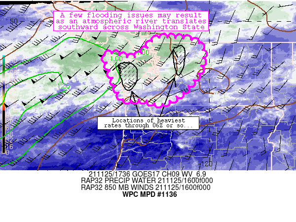
Areas affected...western Washington State

Concerning...Heavy rainfall

Valid 251745Z - 260600Z

Summary...An atmospheric river will gradually shift southward
across portions of western Washington State through 06Z,
potentially leading to a few runoff/flooding issues.

Discussion...Strong onshore flow so far has been confined to areas
of far northwestern Washington State and adjacent areas of British
Columbia as an axis of 50-60 kt southwesterly 850mb flow maintains
moisture and lift while oriented perpendicular nearby terrain
features.  The onshore flow regime has promoted 0.1-0.25 inch/hr
rain rates (based on MRMS operational guidance) so far this
morning along the windward side of the Olympics northeastward
toward the Cascades north of Seattle.  The heaviest rainfall rates
have materialized in the Olympics over the past hour or so.  The
pattern was also maintaining a moist airmass especially along
coastal areas of Washington State, where 1+ inch PW values were
noted in objective analyses.

With time, the mid-level wave helping to foster the enhanced 850mb
flow will shift onshore across British Columbia and western
Washington.  The axis of 850mb flow will shift slowly southward as
a result while gradually weakening.  Models continue to depict
areas of heavier rainfall (potentially exceeding 0.5 inch/hr) that
will spread southward from the Olympics into additional coastal
areas of western Washington in tandem with the 850mb jet.  A
second area of locally heavy rainfall rates could materialize on
the windward side of the Cascades this afternoon as well.  12Z
HREF guidance suggests that heavier rainfall rates will exist
through 05Z or so before tapering off thereafter.  The axis of
rainfall rates should fall in areas prone to runoff, with FFG
values of 0.5-1 inch/three-hour thresholds noted especially along
the Cascades.  As these FFG thresholds are approached through the
afternoon, a few flooding issues are expected to potentially
materialize.

Cook

ATTN...WFO...OTX...PDT...PQR...SEW...

ATTN...RFC...NWRFC...NWC...

LAT...LON   49202246 49172106 48922045 48212029 47362062
            46582131 46452153 46082227 46302312 46272392
            46572425 48402493 48382423 48262359 48642301
Last Updated: 1247 PM EST Thu Nov 25 2021
|


