| WPC Met Watch |
|
|
Mesoscale Precipitation Discussion: #1137 (2021) |
|
(Issued at 126 PM EST Thu Nov 25 2021
) |
|
| MPD Selection |
|
|
|
|
|

Mesoscale Precipitation Discussion 1137
NWS Weather Prediction Center College Park MD
126 PM EST Thu Nov 25 2021

Areas affected...south Texas

Concerning...Heavy rainfall...Flash flooding possible

Valid 251825Z - 260025Z

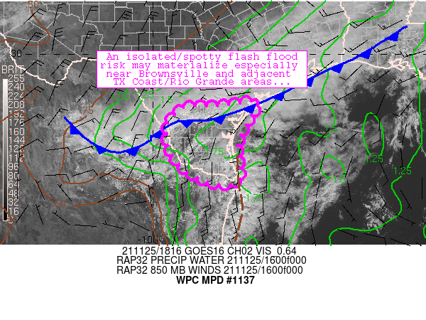
Summary...Gradual destabilization is resulting in a few areas of
deepening convection.  These trends should continue through the
afternoon along with a spotty flash flood threat near the Rio
Grande and south Texas coast.

Discussion...A seasonably strong cold front was making steady
southward progress through central/south Texas as of 18Z.  South
of this front, isolation and weak low-level warm advection was
allowing for maintenance of a moist, weakly unstable, and weakly
capped airmass characterized by 1.6-1.8 inch PW values and 1500
J/kg MUCAPE.  A few areas of slow-moving convection were noted and
focused along a couple of surface features: 1) the
southward-moving cold front and 2) along a weak/diffuse trough
oriented parallel to the Texas/northeastern Mexico coastline.
Based on MRMS analyses, these efficient rainfall producers were
resulting in estimates of 1-2 inch/hr rainfall rates in a few
spots - though these rates were generally below FFG thresholds
areawide.

The approaching front, weak surface convergence along the front,
and localized convective processes (i.e., outflows) are expected
to maintain slow-moving convection across the discussion area as
long as sufficient surface-based instability can persist inland
ahead of the surging front.  Models/observations suggest that this
potential should exist through at least 22-23Z, with the longest
residence time of unstable area (and greatest flash flood risk)
located along the south Texas coast and Rio Grande areas.  Where
convection is able to persist and/or repeat, a quick 2-3 inches of
rainfall will be possible.  These rates are most likely to
overwhelm hydrologically sensitive (i.e., urbanized) areas
especially near Brownsville Metro - especially if convection near
the coast can develop westward/inland this afternoon.  The overall
flash-flood threat is expected to remain fairly isolated and
spotty, however.

Cook

ATTN...WFO...BRO...CRP...

ATTN...RFC...WGRFC...NWC...

LAT...LON   28439683 28379652 27599702 26939723 26329714
            25969711 25759733 25749805 26239896 26829947
            27389953 27689955 28239899 28299779
Last Updated: 126 PM EST Thu Nov 25 2021
|


