| WPC Met Watch |
|
|
Mesoscale Precipitation Discussion: #1176 (2022) |
|
(Issued at 620 PM EST Thu Dec 29 2022
) |
|
| MPD Selection |
|
|
|
|
|

Mesoscale Precipitation Discussion 1176
NWS Weather Prediction Center College Park MD
620 PM EST Thu Dec 29 2022

Areas affected...southwest OR & northwest CA

Concerning...Heavy rainfall

Valid 292316Z - 300916Z

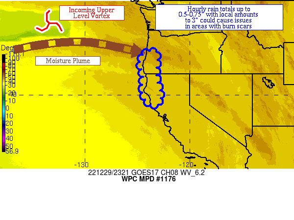
Summary...Heavy rainfall should increase in intensity as a front
moves into the region.  Hourly rain totals of 0.5"+ and local
amounts of 3" could lead to issues in area burn scars.

Discussion...An occluded and warm front are approaching southwest
OR and northwest CA over the next several hours well to the east
of a cyclone currently crossing the 140th meridian.  An upper
level vortex near 47N 133W is helping to direct a plume of
moisture into southwest OR at the present time.  Precipitable
water values of 0.7-0.9" lie over the area per GPS data, and are
rising in advance of the incoming system.  Instability is
negligible at this time.  Southwest flow at 850 hPa is 20-30 kts
per area VAD wind profiles.  Divergence aloft is increasing ahead
of an upper level vortex, currently approaching the 130th meridian.

The 18z HREF signal for 0.5"+ an hour starts registering a signal
after 01z as the fronts near, with the probabilities increasing
above 50% past 04z as the fronts move inland.  This is due to
strengthening 850 hPa inflow, up to 60 kts per recent RAP
guidance, intersecting the terrain as well as boundary layer
moisture convergence increasing as the frontal system sloshes
ashore.  Precipitable water values are forecast to rise to
1-1.25", which is 2-2.5 sigmas above the average for this time of
the year.  Guidance indicates that rainfall should be in decline
after 08z, so chose 09z at this discussion's horizon.  Hourly rain
totals into the 0.5-0.75" range and local amounts to 3" are
anticipated, which would be most problematic in area burn scars.

Roth

ATTN...WFO...EKA...MFR...PQR...STO...

ATTN...RFC...CNRFC...NWRFC...NWC...

LAT...LON   44122317 42062319 39412278 39042388 40432458
            41672445 43012477 43962442
Last Updated: 620 PM EST Thu Dec 29 2022
|


