| WPC Met Watch |
|
|
Mesoscale Precipitation Discussion: #1188 (2023) |
|
(Issued at 100 PM EST Mon Dec 04 2023
) |
|
| MPD Selection |
|
|
|
|
|

Mesoscale Precipitation Discussion 1188
NWS Weather Prediction Center College Park MD
100 PM EST Mon Dec 04 2023

Areas affected...Pacific Northwest

Concerning...Heavy rainfall...Flash flooding possible

Valid 041800Z - 050600Z

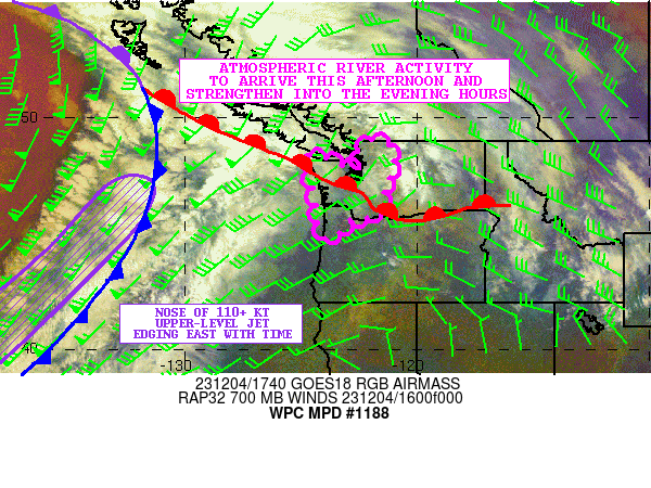
SUMMARY...A well-defined surge of atmospheric river activity will
arrive this afternoon across the Pacific Northwest which will
strengthen this evening. Increasing rainfall rates and storm
totals over time will increase the threat of areal runoff problems
and urban flooding.

DISCUSSION...The latest GOES-W Airmass RGB and WV suite shows a
strong deep layer closed low focused over the northeast Pacific
Ocean to the south of the Gulf of Alaska near 50N 145W. This
energy is gradually advancing off to the east and will be driving
a rather significant atmospheric river into the Pacific Northwest
this afternoon and tonight. The nose of a 110+ kt upper-level jet
is forecast to round the base of the broader upper trough over the
next 6 to 12 hours which will shift the height falls closer into
the coastal ranges, Olympic Peninsula, and the Cascades along with
a well-defined cold front.

Strong warm air advection and moisture transport ahead of the cold
front and in the wake of a warm front lifting northeast across the
Pacific Northwest today will foster increasing rainfall rates into
especially the southwest facing slopes of the Olympic Peninsula
initially, and then with time inland into western slopes of the
Washington Cascades heading through the late afternoon and evening
hours. Coastal ranges farther south down into southwest Washington
and far northwest Oregon will see much of this concentration of
heavier rainfall rates arriving tonight.

Enhanced deep layer southwest flow out ahead of the upper trough
is forecast to drive IVT values upwards of 750 to 1000 kg/m/s into
the terrain, with these values peaking over the Olympic Peninsula
in the 21Z to 03Z time frame, and the Cascades and the adjacent
coastal ranges down to the south peaking more into the 00Z to 06Z
time frame. The overall strength of the moisture transport may
begin to subside just a tad by late this evening, but the overall
axis of the atmospheric river will also be slowing its advance off
to the east as the approaching cold front prepares to cross the
Olympic Peninsula and adjacent coastal ranges.

The 12Z HREF guidance supports rainfall rates increasing into the
0.50" to 0.75"/hour range in connection with the arrival of the
stronger IVT values, with some peak rates, especially over the
Olympic Peninsula likely getting into the 0.75" to 1"/hour range
which aside from very strong orographic ascent will also be aided
by some instability with MUCAPE values locally reaching over 250
J/kg.

At least for the next 12 hour period, additional rainfall amounts
of 3 to 6 inches are likely over the Olympic Peninsula with
slightly lesser amounts over the northern Washington Cascades.
Areas farther south over the Cascades and the coastal ranges will
see somewhat lesser totals that may reach 2 to 3 inches.

This next round of heavier rainfall rates/totals coupled with
rising snow levels, snowmelt over the higher terrain, and wet
antecedent conditions will increase the threat of areal runoff
problems and urban flooding.

Orrison

ATTN...WFO...OTX...PDT...PQR...SEW...

ATTN...RFC...NWRFC...NWC...

LAT...LON   48982142 48642104 48142099 47592106 47312123
            47042147 46682139 46452145 46002156 45642202
            45772247 45342320 44922336 44722381 45172420
            46172427 47482459 48032485 48432445 48232390
            48072350 47842306 47802268 47822244 48172242
            48622250 48972199
Download in GIS format: Shapefile
| KML
Last Updated: 100 PM EST Mon Dec 04 2023
|


