| WPC Met Watch |
|
|
Mesoscale Precipitation Discussion: #0126 (2019) |
|
(Issued at 643 PM EDT Sun Apr 14 2019
) |
|
| MPD Selection |
|
|
|
|
|

Mesoscale Precipitation Discussion 0126...Corrected
NWS Weather Prediction Center College Park MD
643 PM EDT Sun Apr 14 2019

Corrected for Typo in second discussion paragraph

Areas affected...Portions of the Mid-Atlantic States

Concerning...Heavy rainfall...Flash flooding possible

Valid 142239Z - 150239Z

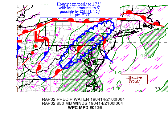
Summary...Thunderstorms within a rain band have been showing some
uptick in coverage and intensity as of late.  Hourly totals to
1.75" with local amounts to 3" are possible.

Discussion...The surface analysis is complex to the east of a
deepening cyclone, with a weak wedge signature being reinforced by
a batch of showers and thunderstorms which have been moving up the
Blue Ridge Mountains just to the east of an upper level trough.
Precipitable water values of 1.3-1.5" exists here, which have been
slowly rising.  MU CAPE values to the east and south of the band
are 500+ J/kg and remaining stable.  Effective bulk shear of 45-55
knots exist here, which when combined with unidirectional flow out
of the southwest has organized this band.

The mesoscale guidance is really struggling concerning the amounts
possible here, which is being clarified by the recent uptick.
Between the training possible in this band and the potential for
some of the thunderstorms to become mesocyclones, hourly rain
totals to 1.75" and local amounts to 3" are possible.  The 18z
HREF probabilities of 0.5"/1" an hour are suprisingly low given
the environment within which this band exists.  The 12z Canadian
Regional and the 12z ARW appear to have the best grasp at
convective expections over the next several hours.  The
Galvez-Davison index hints that the convective uptick should
continue until at least 00z before fading thereafter.  Whatever
signal for heavy rainfall is seen in the HREF probabilities
appears to match this, showing either steady state activity or a
slight uptick through 02z before fading thereafter.  Due to this,
used a four hour window for the MPD.

Roth

ATTN...WFO...AKQ...ALY...BGM...CTP...LWX...OKX...PHI...

ATTN...RFC...MARFC...NERFC...

LAT...LON   41847424 41257445 40867482 39367651 37737871
            38407894 40237746 41647537
Last Updated: 643 PM EDT Sun Apr 14 2019
|


