| WPC Met Watch |
|
|
Mesoscale Precipitation Discussion: #0180 (2023) |
|
(Issued at 803 PM EDT Wed Apr 12 2023
) |
|
| MPD Selection |
|
|
|
|
|

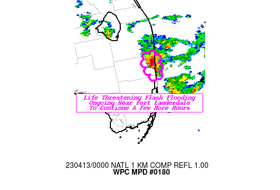
Mesoscale Precipitation Discussion 0180
NWS Weather Prediction Center College Park MD
803 PM EDT Wed Apr 12 2023

Areas affected...Fort Lauderdale Area

Concerning...Heavy rainfall...Flash flooding likely

Valid 130000Z - 130300Z

SUMMARY...Significant flash flooding ongoing in and around the
Fort Lauderdale area is expected to continue as an additional 2-5"
of rainfall is expected over the next few hours.

DISCUSSION...A cluster of stationary thunderstorms have been
producing copious amounts of rainfall over portions of the Fort
Lauderdale area with no sign of them slowing down for another hour
or two. Some locations have already received 10-14" of rainfall
since 8AM. The atmosphere remains primed for these storms to
contain efficient warm rain processes featuring; a highly
saturated profile (>90% RH at low-mid levels), a classic skinny
CAPE profile, warm cloud layer depths of 11,000 kft, storm motions
<10 kts, and effective bulk wind shear values >30 knots to sustain
these cells. AMX VAD wind profiler shows a persistent 15-25 knots
of easterly inflow which continues to provide ample moisture from
off the FL coast for a couple more hours.

Most hi-res guidance is on board with another 2-5" of rainfall
expected over the next 2-3 hours, meaning cumulative totals since
8AM may reach as high as 12-18" in the Fort Lauderdale-Hollywood
area. With the impressive rainfall totals and significant flooding
ongoing for some areas, this will only exacerbate what is a
life-threatening situation. Expect more street flooding to ensue,
and with the sun setting, areas of flooding will become
increasingly more difficult to identify for motorists.

Mullinax

ATTN...WFO...MFL...

ATTN...RFC...SERFC...NWC...

LAT...LON   26348026 26338006 26038004 25908012 25978021
            26178029
Last Updated: 803 PM EDT Wed Apr 12 2023
|


