| WPC Met Watch |
|
|
Mesoscale Precipitation Discussion: #0180 |
|
(Issued at 908 PM EDT Fri Apr 25 2025
) |
|
| MPD Selection |
|
|
|
|
|

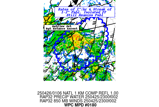
Mesoscale Precipitation Discussion 0180
NWS Weather Prediction Center College Park MD
908 PM EDT Fri Apr 25 2025

Areas affected...Northeast OH...Northwest PA...WV Stovepipe...Far
Southwest NY...

Concerning...Heavy rainfall...Flash flooding possible

Valid 260115Z - 260615Z

SUMMARY...Localized widely scattered convective cells capable of
producing 1"/hr rates with a low-end risk of 1-2" totals to
continue to pose isolated incident or two of possible flash
flooding overnight.

DISCUSSION...GOES-E WV suite depicts an anti-cyclonically curved
cirrus shield indicative of right entrance positive
ascent/divergence across the Ontario peninsula into the Lake Erie
region.  Nose of well above average (95th-99th percentile)
moisture feed/LLJ or warm conveyor belt has been persistent from
the southwest aided by orographic ascent through the western
Allegheny Plateau.  Some remaining conditionally unstable air with
500-750 J/kg of CAPE appears to be aiding remaining convective
cores across far NE OH into NW PA at this time with some cycling
of cooling tops noted in 10.3um EIR.  Given 1.25-1.4" Total
PWats...rates of 1"/hr still remain observed though likely to
downturn slightly over the next few hours with further loss of
surface heating.  Still orientation of convection is broad enough
in the WAA regime and fairly parallel to the deeper layer steering
to support some short-term repeating/training potentially
resulting in a spot or two of 1.5-2" totals in 1-2 hours.  Given
complex terrain, these rates and totals are in the range of the
1-1.5"/hr and/or 1-2"/3hr FFG values to be exceeded.  As such,
localized flash flooding remains possible.

While the instability will be decreasing due to low level heating,
the main mid to upper level trough remains upstream with CAA aloft
likely to steepen mid-level lapse rates to maintain weak CAPE of
250-500 J/kg.  As such, there will remain potential for weaker
.25-.5"/hr rate showers along/ahead of the cold front crossing the
area.  This may aggravate some areas that were near or just
exceeding FFG and result in increased runoff through the overnight
period past 06z with streaks of an additional .5-1".

Gallina

ATTN...WFO...BUF...CLE...CTP...PBZ...

ATTN...RFC...MARFC...NERFC...OHRFC...NWC...

LAT...LON   42547841 42207786 41497774 40667823 40037945
            39758064 39858135 40218170 40948194 41388187
            41918102 42417952
Download in GIS format: Shapefile
| KML
Last Updated: 908 PM EDT Fri Apr 25 2025
|


