| WPC Met Watch |
|
|
Mesoscale Precipitation Discussion: #0193 (2020) |
|
(Issued at 959 PM EDT Thu May 14 2020
) |
|
| MPD Selection |
|
|
|
|
|

Mesoscale Precipitation Discussion 0193
NWS Weather Prediction Center College Park MD
959 PM EDT Thu May 14 2020

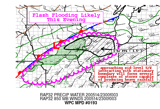
Areas affected...Eastern Iowa...Northern Illinois...Northern
Missouri...Eastern Kansas

Concerning...Heavy rainfall...Flash flooding likely

Valid 150159Z - 150759Z

Summary...Flash flooding will be likely through the evening hours
as several clusters of thunderstorms producing heavy rainfall
converge over the outlook area. Hourly totals in excess of 2" will
be possible with localized totals through 08Z in the 4-5".

Discussion...GOES-East IR imagery continued to show rapidly
cooling cloud tops over southeastern Iowa and northern Missouri as
of 0130Z associated with several convective clusters forming
along/ahead of a nearly stationary boundary. Southerly low level
flow impinging on the boundary has led to an environment
characterized by dewpoints in the low/mid 60s and temperatures in
the upper 70s to low 80s, yielding SBCAPE of 2000-2500 J/kg as of
01Z. Aloft, water vapor imagery shows the approach of a couple
feature, one shortwave along the Minnesota/Canadian border with
another shortwave quickly moving off the Rockies across the
north-central Plains, both of which are providing the large scale
forcing for ascent.

Over the next several hours, instability should remain sufficient
ahead of the stationary boundary with an increasing flux of low
level moisture transport characterized by 850 mb flow increasing
from around 20-25 kts to over 35 kts by 04Z. Additionally, there
should be some parallel alignment between the mean flow and storm
motion to favor some training/repeating rounds. Based on current
radar trends, a couple localized heavier footprint areas are
expected. The first being across eastern IA and northern IL
(perhaps far northeast MO) where potential for additional 2-4"
appear possible. Further south, convection currently over eastern
KS may congeal into another cluster that moves into west-central
MO. Here, better instability may lead to higher totals (2-4",
locally higher) though the confidence in the storm evolution is
not as clear. The recent runs of the HRRR have been handling some
of this activity fairly well and was used for the outlook area.

Portions of the outlook area have picked localized heavy rainfall
from earlier today/last evening. As such, some areas have reduced
flash flood guidance (1-hr FFG under 1.5") and based on the latest
HREF probabilities showing some moderate probs of 2" in 1-hr and
high probs of 1" in 1 hour for a few hours, some flash flooding
will be likely this evening.

Taylor

ATTN...WFO...DMX...DVN...EAX...ICT...ILX...LOT...LSX...SGF...
TOP...

ATTN...RFC...ABRFC...MBRFC...NCRFC...NWC...

LAT...LON   42519081 42268821 41488771 40718817 38109404
            38439688 40329486 40739433 41259360
Last Updated: 959 PM EDT Thu May 14 2020
|


