| WPC Met Watch |
|
|
Mesoscale Precipitation Discussion: #0274 (2019) |
|
(Issued at 905 PM EDT Wed May 22 2019
) |
|
| MPD Selection |
|
|
|
|
|

Mesoscale Precipitation Discussion 0274
NWS Weather Prediction Center College Park MD
905 PM EDT Wed May 22 2019

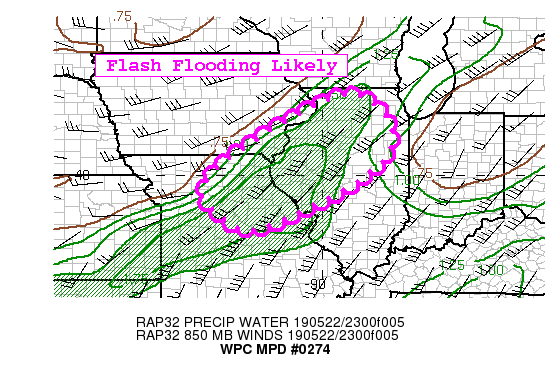
Areas affected...Northeast Missouri...Central/Northern Illinois

Concerning...Heavy rainfall...Flash flooding possible

Valid 230105Z - 230705Z

Summary...Flash flooding will be likely through portions of the
overnight hours as several clusters of thunderstorms train over
areas that are well saturated with low flash flood guidance
values. Areal totals of 1-3" with locally higher amounts will be
possible through 07z.

Discussion...Convection blossoming across central Missouri into
western/northwest Illinois this evening per regional radar returns
and cooling cloud tops from the latest GOES-16 IR imagery. The
environment remains very conducive for high producing rainfall
thunderstorms, characterized by precipitable water values 1.3 to
1.8" all within a belt of 2000-2500 J/kg of SBCAPE.

Ground soils are very saturated with 7 day departures running 400
to 600 percent of normal in the outlook area, and recent FFG
values are low (1-1.5"/1 hr and 1.5-2.0"/3 hr). Recent streamflow
data from the National Water Model showed that very above normal
conditions in the outlook area, with the expected rainfall to lead
to excessive runoff.

A consensus of the latest hi-res guidance shows potential for 1-3"
areal averages through 07z with isolated amounts of 3-5" possible
where convection trains or backbuilds. The NAM conest and the
latest run of the HRRR seem to be capturing the activity the best
compared to reality.

As a result, instances of flash flooding will be likely across
central/northern Missouri into western/northwest Illinois through
07z, and may continue further into the overnight hours.


Taylor

ATTN...WFO...DMX...DVN...EAX...ILX...LOT...LSX...

ATTN...RFC...MBRFC...NCRFC...OHRFC...

LAT...LON   42308912 41578811 40718808 40038874 39358984
            38459192 38709271 39429344 40139308 40979196
            41729073
Last Updated: 905 PM EDT Wed May 22 2019
|


