| WPC Met Watch |
|
|
Mesoscale Precipitation Discussion: #0305 (2019) |
|
(Issued at 844 PM EDT Sun May 26 2019
) |
|
| MPD Selection |
|
|
|
|
|

Mesoscale Precipitation Discussion 0305
NWS Weather Prediction Center College Park MD
844 PM EDT Sun May 26 2019

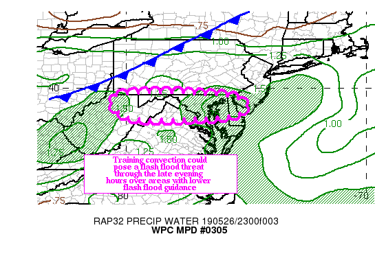
Areas affected...Northern WV...northern MD into northern DE

Concerning...Heavy rainfall...Flash flooding possible

Valid 270045Z - 270415Z

Summary...Convection ahead of a cold front could train across
portions of the northern Mid Atlantic states through the late
evening hours, posing a flash flood threat.

Discussion...Regional radars showed a developing line of
convection extending from northern WV across northern MD into
north central DE early this evening. The convection is firing in
an axis of 1000 J/KG of MLCAPE over this area, and the GOES clean
IR image is showing cooling tops with the cells along the line.
Additionally, cooling cloud tops on the IR loop showed clusters
strengthening across northern WV, with the convection at the end
of the line.

Hourly rainfall rates are generally in the 1.00/1.25 inch range
across northern WV into northern MD, though based on the radar
presentation, these values could be inflated by the presence of
hail. In the short term, the instability is expected to remain in
place through about 27/04z, though as daytime heating is lost, the
instability could become more elevated with time. Short wave
energy across central KY is expected to provide sufficient
synoptic scale ascent to maintain the current convection through
that time.

Across northern WV, the convective cluster is expected to keep
moving, as it appears to be mostly cold pooled dominated at this
time. Three hour flash flood guidance values are as low as
1.00/1.50 inches, so despite the progressive nature of the
cluster, there is still a flash flood threat, though the threat
could end before 27/0130z.

Further east across northern MD into northern DE, the 850-400 mb
mean flow remains more or less aligned to the propagation vectors
through 27/04z. This would continue to foster an environment
conducive to training, so the wind/hail threat could transition
into a flash flood threat through the early evening hours.  Total
rainfall between 2.00/3.00 inches are possible, especially across
portions MD, where training could occur through the late evening
hours.

Three hour flash flood guidance values across northern MD into
northern DE generally above 2.50 inches, and training could allow
some locations in northern MD to reach or even exceed these
values. At this point, because of the relatively high guidance,
flash flood is considered possible through the late evening hours.

Hayes

ATTN...WFO...CTP...LWX...PBZ...PHI...RLX...

ATTN...RFC...MARFC...OHRFC...

LAT...LON   39767669 39437511 38887558 38737926 39068033
            39738032
Last Updated: 844 PM EDT Sun May 26 2019
|


