| WPC Met Watch |
|
|
Mesoscale Precipitation Discussion: #0321 (2019) |
|
(Issued at 319 PM EDT Tue May 28 2019
) |
|
| MPD Selection |
|
|
|
|
|

Mesoscale Precipitation Discussion 0321
NWS Weather Prediction Center College Park MD
319 PM EDT Tue May 28 2019

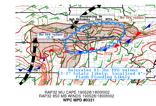
Areas affected...Southern IA...Northern MO...Northeast KS...Far
Southeast NEB...

Concerning...Heavy rainfall...Flash flooding likely

Valid 281920Z - 290020Z

SUMMARY...Increasing coverage/magnitude of elevated thunderstorms
moving through saturated soil conditions pose possible flash
flooding this afternoon/evening.

DISCUSSION...RADAR mosaic and GOES-16 Visible imagery depict
multiple clusters of thunderstorms that are steadily expanding in
coverage with cooling/intensifying trends.  Lightning network also
depicts this well particularly with the surge of strikes in
southwest IA.  Surface analysis depicts a stationary frontal
boundary enhanced by earlier outflow boundaries across northeast
KS into northern MO from S of MHK to S of STJ to CDJ to N of IRK.

Much of the clustered convection has crossed the boundary and are
clearly elevated in nature, feeding off modest low to mid-level
instability with RAP analysis depicting 2000 J/kg of MUCAPE as far
north as the IA/MO border as well as backing but solid 20-30kt
southerly 850mb flow.  This flow is generally stalls with speed
convergence across southeast NEB into southern IA; and as such
there is a sharp instability/moisture gradient along and just
north of I-80 across central IA.  Moisture pooled has totaled to
1.5" mainly from the 900mb to 650mb per layered PW and RAP
analysis supporting solid rainfall efficiency even at this time
with rates of 1-1.5"/hr.

Aloft, GOES-16 WV suite depicts increased diffluence as the
mid-upper levels increase with shortwave ridging.  Additional, the
right entrance of the jet speed max has lifted through enhancing
further divergence aloft across the Missouri River Valley.  With
convergent low level flow, steering flow will also back more
westerly and propagate clusters eastward along across S IA, not in
the areas most affected last evening (over E NEB) were FFG values
are very low, but still across areas that are nearly saturated
(80-90% per Natl Water Model) and AHPS 2 week anomalies well above
normal.  As such much of the rainfall will quickly flow into
abnormally high tributaries leading to backing up and quicker
flash flooding/flooding conditions.   HREF probabilities suggest a
broad area of 1" with probabilities over 70% covering much of
southern IA and the northern row of MO through 00z, with a good
area of 10-20% over 3"/3hrs as well.  As such flash flooding is
considered likely over the next 4-6hrs (especially if/when more
surface rooted convection develops out of northeast KS and again
tracks through the same areas closer toward 23-00z.

Gallina

ATTN...WFO...DMX...DVN...EAX...LSX...OAX...TOP...

ATTN...RFC...MBRFC...NCRFC...

LAT...LON   41819253 41439118 40169198 39519362 39099564
            39239669 40049678 40899589 41529484 41789384
Last Updated: 319 PM EDT Tue May 28 2019
|


