| WPC Met Watch |
|
|
Mesoscale Precipitation Discussion: #0324 (2019) |
|
(Issued at 615 PM EDT Tue May 28 2019
) |
|
| MPD Selection |
|
|
|
|
|

Mesoscale Precipitation Discussion 0324
NWS Weather Prediction Center College Park MD
615 PM EDT Tue May 28 2019

Areas affected...Eastern KS...Kansas City/St. Joseph area of MO

Concerning...Heavy rainfall...Flash flooding possible

Valid 282215Z - 290215Z

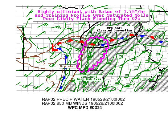
SUMMARY...Training Cells in deepest moisture axis falling over
saturated soils.  Flash flooding likely

DISCUSSION...GOES-16 Vis/IR suite denotes the dry slot quite well
from Pottawatomie county KS toward the SSW to Sumner county KS and
beyond into western OK.  East of this area, persistent low stratus
in deep moisture axis from confluence of Western Gulf low level
moisture and subtropical moisture from eastern tropical Pacific
(per CIRA Layered PW) leading to a corridor of 1.75" total PWs
over eastern KS.  While, the dry slot has extreme instability due
to the mid-level drying/steep lapse rates, there has been
sufficient instability a secondary maxima around 2500 J/kg.  Low
level confluence/convergence was sufficient to break the limited
capping in the moist axis allowing for a line of intense updrafts
with supercell characteristics from Jackson to Lyon county
currently.  Being just east of the best instability, deep layered
height-falls also supports broadened 500-1000 thickness pattern
and therefore reduced propagation vectors, with mean inflow of
30-35kts from about 200 degrees on the LLJ, nearly opposite to the
mean cloud-bearing flow of 40kts from 225ish.  In combination with
supercell rotation, propagation/cell motions are limited to
5-10kts and fairly parallel to the orientation of the moisture
axis.

Additionally, the moist axis is also aligned with the greatest
saturated soils with hourly FFG values around 1.5" likely
overestimated anyway given National Water Model saturation field
suggest .85-1.0 soil saturation ratios to a depth of 40cm.  With
ample moisture flux convergence/confluence and values of this
range, rain-rates and totals of 2-4" through 02z are likely to
exceed even these inflated FFG values, so flash flooding is
considered likely.

The greatest uncertainty is the southward expansion of the
convective line into the Southern Flint Hills, but have
encompassed this lowered FFG area just in case.   Currently,
capping appears strong though increasing showers/thunderstorms
across northeast Oklahoma as the 7H temps are cooling with the
approach of a weak subtropical stream shortwave.  Will keep alert
for the possible southward expansion over the next few hours

Toward 00z...eastern KS cells will near/approach the frontal
boundary across northeast KS into N Missouri, where elevated
convection is leading to ongoing flooding/flash flooding.  Cells
will meld into the complex and further expand areal coverage of
flooding conditions leading to broad area of life-threatening
flash flooding through the evening including the I-29 corridor
between St. Joseph and Kansas City Metro before the shortwave
angles eastward and allows for increased eastward propgation of
the moisture axis and embedded convection.


Gallina

ATTN...WFO...EAX...ICT...SGF...TOP...

ATTN...RFC...ABRFC...MBRFC...

LAT...LON   39939504 39839455 39409429 38309477 37509559
            37189598 37069644 37149674 37299692 37589684
            38279668 38409661 39319616 39879589
Last Updated: 615 PM EDT Tue May 28 2019
|


