| WPC Met Watch |
|
|
Mesoscale Precipitation Discussion: #0325 (2019) |
|
(Issued at 840 PM EDT Tue May 28 2019
) |
|
| MPD Selection |
|
|
|
|
|

Mesoscale Precipitation Discussion 0325
NWS Weather Prediction Center College Park MD
840 PM EDT Tue May 28 2019

Areas affected......Southeast NE...Northeast KS...Northern
MO...Southern IA...Northern and Central IL...

Concerning...Heavy rainfall...Flash flooding possible

Valid 290038Z - 290438Z

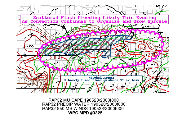
Summary...Additional flash flooding will continue this evening as
convective clusters, including supercells, become more widespread.
Hourly rainfall rates between 1 and 2 inches are likely, with
embedded heavier rates underneath the strongest cells. Rainfall
totals of 3 to 5 inches are anticipated in scattered areas through
0430 UTC.

Discussion...Unseasonably robust upper level forcing, owing to a
shortwave approaching from the central Plains along with
right-entrance region upper jet forcing via the 250 mb jet streak
over the Upper Midwest-Upper Great Lakes region, combined with a
typical warm season thermodynamic environment will continue to
support upscale growth of convection with an elevated flash flood
threat through the evening hours. MUCapes between 1000-2000+ j/kg
across the outlook area, along with PW values near 1.75", will
maintain the potential for 2+ inch/hr rainfall rates. Moreover,
south-southwest low-level inflow of 35-40 kts will veer more
southwesterly this evening, aligning nearly parallel to the mean
850-300 mb flow. This will likely increase the upwind propagation
potential with time, thereby enhancing the threat for cell
back-building and training.

Flash flooding will become increasingly likely as the evening
progresses, given the upscale growth and vigor of the convection,
along with the wet antecedent soils. Three hourly flash flood
guidance (FFG) across much of the outlook area is between 1-1.5
inches, with areas less than an inch. Most high-res CAM guidance
indicate pockets of 3-5 inch totals through the MPD outlook period.

Hurley

ATTN...WFO...DMX...DVN...EAX...GID...ICT...ILX...LOT...LSX...
OAX...TOP...

ATTN...RFC...ABRFC...MBRFC...NCRFC...OHRFC...

LAT...LON   42169004 42008825 41428763 40778760 40048811
            39608898 39299011 39069189 38929316 38799505
            38859680 39219805 39849869 40639858 41309728
            41729541 41959377 42109180
Last Updated: 840 PM EDT Tue May 28 2019
|


