| WPC Met Watch |
|
|
Mesoscale Precipitation Discussion: #0329 (2019) |
|
(Issued at 1236 AM EDT Wed May 29 2019
) |
|
| MPD Selection |
|
|
|
|
|

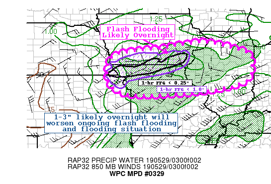
Mesoscale Precipitation Discussion 0329
NWS Weather Prediction Center College Park MD
1236 AM EDT Wed May 29 2019

Areas affected...Southern Iowa...Northern Missouri...West Central
Illinois

Concerning...Heavy rainfall...Flash flooding likely

Valid 290435Z - 291035Z

Summary...Another round of heavy rainfall tracking along the
Iowa/Missouri border will move into areas with dangerously low
flash flood guidance due to recent thunderstorms. Flash flooding
will be likely with an additional 1-3" overnight.

Discussion...Regional radar mosaic across the mid-MS River Valley
shows several clusters of storms as of 04z. A surface analysis
showed a stationary boundary draped from around the KC metro east
toward central Illinois. Ongoing convection across
northern/eastern MO has been working east/southeast into the
better instability axis, helping to push this effective boundary
southward as well. Meanwhile, low pressure was analyzed across
northeast Kansas.

Unusually strong upper level forcing over the outlook area thanks
to a closed low over western Nebraska, will provide the large
scale forcing for ascent over the outlook area. The thermodynamic
environment is characterized by mostly elevated instability of
around 1000 to 1500 J/kg from the southern third of Iowa into
northern Missouri. This should persist for the next several hours
as the low level jet and moisture transport axis noses into
northeast MO and western IL. This should push the complex of
storms eastward for a few hours then gradually east/southeast
along the instability gradient. PWs of 1.5 to 1.7" should persist
through about 08z, until the best moisture transport moves
northeast.

Some of the 00z guidance is handling the activity better compared
to early runs. The 00z NAM conest and 03z HRRR are probably
handling the activity the best, but likely are too quick to
dissipate the storms after 06z.

Radar estimates show hourly rates of around 1" with the activity
working through northwest MO, which matches well with the area
mesonet observations in the last hour (0.68" in Maryville and
0.67" in Bolclow). Despite its faster forward movement, which
might limit some rainfall totals, it will move over areas that
just can't handle much more water. Dangerously low flash flood
guidance exists over a large area within the outlook area, with
1-hr values as low as 0.25" (or less). 3-hr values aren't much
higher. Streamflow and soil saturation is maxed out, so the
additional rainfall will only exacerbate the flooding situation.
This could create some dangerous or significant flash flooding or
flooding issues overnight.

Taylor

ATTN...WFO...DMX...DVN...EAX...ILX...LOT...LSX...OAX...TOP...

ATTN...RFC...MBRFC...NCRFC...OHRFC...

LAT...LON   41859018 41268790 40698772 40208768 39718795
            39538842 39378883 39049086 38879355 38969499
            39669591 40989572 41339454 41539284 41749160
Last Updated: 1236 AM EDT Wed May 29 2019
|


