| WPC Met Watch |
|
|
Mesoscale Precipitation Discussion: #0329 (2024) |
|
(Issued at 435 PM EDT Sun May 26 2024
) |
|
| MPD Selection |
|
|
|
|
|

Mesoscale Precipitation Discussion 0329
NWS Weather Prediction Center College Park MD
435 PM EDT Sun May 26 2024

Areas affected...Portions of the Middle MS and Lower OH Valleys

Concerning...Heavy rainfall...Flash flooding likely

Valid 262035Z - 270235Z

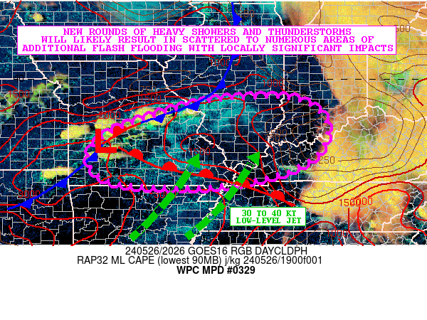
SUMMARY...Numerous areas of showers and thunderstorms will be
redeveloping and expanding in coverage over the next several hours
across areas of central and southern MO and into southern IL,
western KY, and southwest IN. Given locally wet/saturated soil
conditions from earlier rainfall, and the additional rainfall
threat this evening, areas of flash flooding are expected with
some of it locally significant.

DISCUSSION...The mid-afternoon GOES-E Day Cloud Phase RGB
satellite imagery shows convective initiation taking place across
areas of west-central to southwest MO in close proximity to a
surface cold front gradually settling southeast into the middle MS
Valley. The airmass ahead of this across much of central and
southern MO continues the process of recovering in the wake of the
strong early-day QLCS activity which left behind a strong cold
pool. The modification of this cold pool over the last few hours
continues with strong solar insolation/heating and warm air
advection focusing ahead of a wave of low pressure advancing into
southwest MO. This has allowed for the erosion of earlier
low-level CIN, and has fostered MLCAPE values back as high as 2000
to 3000 J/kg.

Convection is expected to rapidly develop and expand in coverage
across areas of central and southern MO over the next 2 to 3 hours
and advance generally off to the east into adjacent areas of
southern IL, southwest IN, and western KY heading through the
mid-evening hours as this downstream airmass also recovers from
the remnants of the aforementioned cold pool. A well-defined
outflow boundary/front remains in place across portions of
southern MO and down into western TN which should gradually return
northeastward over the next several hours and also be a catalyst
for convective redevelopment as a moist/unstable 30 to 40 kt
southwest low-level jet interacts with it.

Rainfall rates with the redeveloping showers and thunderstorms are
expected to reach 1.5 to 2.5"/hour given the return of higher CAPE
values, moisture convergence in vicinity of the aforementioned
fronts/boundaries and favorable shear. A notable concern for
cell-training exists in close proximity to the aforementioned
outflow boundary in particular, which will likely set the stage
for areas of southeast MO, southern IL, southwest IN, and western
KY to see the heaviest focus of rainfall going into the evening
hours.

The 12Z HREF, 12Z NSSL-MPAS guidance, and the 18Z/19Z experimental
WoFS runs suggest additional rainfall totals going through
mid-evening may reach 3 to 6 inches, although there are notable
differences with the placement of the heaviest totals.

Given the wet antecedent conditions from heavy rainfall over the
last 12 to 18 hours, these additional rains are likely to cause
significant runoff concerns with scattered to numerous instances
of flash flooding, and locally considerable impacts going into the
evening hours.

Orrison

ATTN...WFO...ILX...IND...LMK...LSX...MEG...PAH...SGF...

ATTN...RFC...ABRFC...LMRFC...MBRFC...NCRFC...OHRFC...NWC...

LAT...LON   39398837 39248695 38628616 37728628 37148709
            36788811 36489013 36579283 36979375 37599391
            38229322 38709200 39209016
Download in GIS format: Shapefile
| KML
Last Updated: 435 PM EDT Sun May 26 2024
|


