| WPC Met Watch |
|
|
Mesoscale Precipitation Discussion: #0382 |
|
(Issued at 216 PM EDT Fri Jun 06 2025
) |
|
| MPD Selection |
|
|
|
|
|

Mesoscale Precipitation Discussion 0382
NWS Weather Prediction Center College Park MD
216 PM EDT Fri Jun 06 2025

Areas affected...Central Appalachians into the Northern
Mid-Atlantic

Concerning...Heavy rainfall...Flash flooding likely

Valid 061815Z - 070015Z

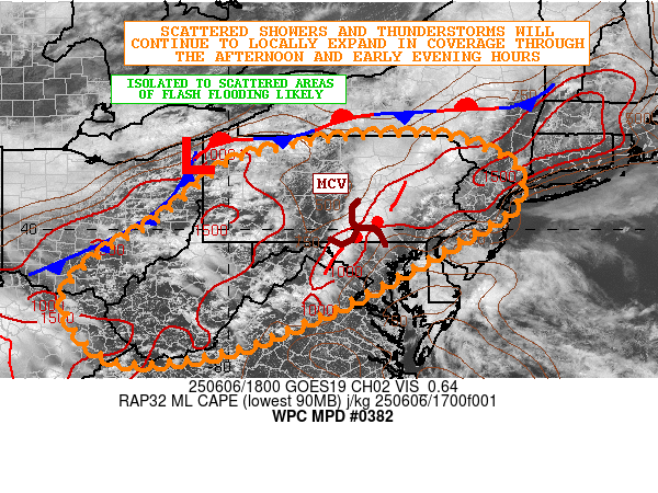
SUMMARY...Showers and thunderstorms will continue to locally
expand in coverage through the afternoon and early evening hours.
Isolated to scattered areas of flash flooding are likely from
heavy rainfall rates and locally wet antecedent conditions.

DISCUSSION...The early afternoon GOES-E visible satellite imagery
along with dual-pol radar shows scattered to locally broken areas
of heavy showers and thunderstorms already impacting southeast OH,
much of WV, western MD and also southwest to northeast PA. Strong
boundary layer heating continues locally which has allowed for
MLCAPE values to rise to as much as 1000 to 1500 J/kg, with the
better instability noted across southeast PA through northern NJ.
However, secondary areas of 1000+ J/kg CAPE values are also noted
across the western slopes of the central Appalachians in the wake
of earlier convection.

Heavy showers and thunderstorms will generally continue to advance
east off the terrain of the Appalachians and Blue Ridge over the
next few hours and get into at least the Piedmont areas of the
northern Mid-Atlantic. There are some question marks about the
I-95 corridor where some pockets of larger scale subsidence are
noted given proximity of a surface low center off the Delmarva,
but as this low pulls away, and additional surface heating takes
place over the next few hours, the I-95 corridor from northern VA
through northeast MD, southeast PA, and into central and northern
NJ may also get into these areas of thunderstorms. Radar imagery
shows a band of strong thunderstorms with high rainfall rates
focused from near Harrisburg, PA down through Martinsburg, WV, and
this band is associated with some evidence of a weak MCV/shortwave
impulse.

Ongoing recover of instability farther west over the central
Appalachians and the western slopes of the terrain is occurring
out ahead of a cold front, but with additional upstream shortwave
energy approaching along with the influence of orographics,
convection will be reloading across these areas going through
early this evening.

Rainfall rates with the stronger storms across the entire region
will likely be 1 to 2 inches/hour, but with some additional spotty
rainfall totals of as much as 2 to 3 inches going through early
this evening. Given the impacts over areas that are already very
moist on the ground, and also the concern for some urban impacts,
isolated to scattered areas of flash flooding will generally be
likely.

Orrison

ATTN...WFO...BGM...CLE...CTP...ILN...JKL...LWX...OKX...PBZ...
PHI...RLX...RNK...

ATTN...RFC...RHA...TAR...TIR...NWC...

LAT...LON   41987566 41777473 41327390 40537389 39747517
            38767691 38047841 37438006 37228239 38398348
            39318287 40188147 41358002 41737872 41957725
Download in GIS format: Shapefile
| KML
Last Updated: 216 PM EDT Fri Jun 06 2025
|


