| WPC Met Watch |
|
|
Mesoscale Precipitation Discussion: #0394 (2022) |
|
(Issued at 901 PM EDT Wed Jun 22 2022
) |
|
| MPD Selection |
|
|
|
|
|

Mesoscale Precipitation Discussion 0394
NWS Weather Prediction Center College Park MD
901 PM EDT Wed Jun 22 2022

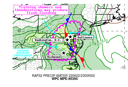
Areas affected...Mid-Atlantic States including the I-95 corridor
from Richmond, VA to Baltimore, MD

Concerning...Heavy rainfall...Flash flooding possible

Valid 230100Z - 230600Z

Summary...Showers and thunderstorms will likely train from north
to south into tonight bringing rounds of heavy rainfall with rain
rates of 1-2"/hr. Flash flooding is possible.

Discussion...The regional radar mosaic this evening depicts
rapidly expanding shower and thunderstorm coverage across the
Mid-Atlantic. This convection is developing along three distinct
boundaries: a cold front approaching from the northwest, a
stationary front wavering across the Mid-Atlantic, and an 850mb
confluence axis/trough. The primary focus is likely to become
oriented from N-S across central MD, including the I-95 corridor,
as easterly flow from the Atlantic and westerly flow from the warm
sector over the Appalachians converges into the stationary
boundary. This is likely already occurring as noted by a rapid
intensification in reflectivity along the boundary within
impressive PWs measured by the 00Z U/A soundings at KWAL and KIAD
of 1.89 and 2.12 inches, respectively, near or above daily records.

Although instability east of this front is minimal, a strong CAPE
gradient exists generally from I-95 west into the Panhandle of WV.
With the near-record PWs in place, and sufficient instability
persisting, any convergent boundaries will likely drive convective
development. Additionally, a modest shortwave embedded within the
unidirectional northerly flow will drive additional ascent to
expand coverage. Rainfall rates have already been estimated by
local radars to be 1-2"/hr, locally higher, and this is progged by
the HREF to persist into tonight. Despite storm motions of 20-30
kts, deep flow parallel to this stationary front suggests a high
likelihood for training, and some areas may receive 2-3" of
rainfall with locally higher amounts.

The high-res differs as to where the greatest threat exists, but
the recent HRRR seems to be capturing the rapid new growth quite
well. This suggests the greatest risk for flash flooding will be
generally along and east of MD route 97, and south into eastern
VA, with some enhancement possible near the Chesapeake Bay due to
land breeze convergence.

Although the area has been dry recently noted by 7-day AHPS
rainfall that is generally just 25% of normal leading to 40cm soil
moisture that is in the bottom 5th percentile according to NASA
SPoRT, this impressive rain rates could quickly lead to runoff,
especially in any urban areas. The training axes are likely to be
pretty narrow, but where they setup to produce the longest
duration of heavy rain, flash flooding could occur even outside of
the more urban/impermeable surfaces.


Weiss

ATTN...WFO...AKQ...BGM...CTP...LWX...PHI...RNK...

ATTN...RFC...MARFC...SERFC...NWC...

LAT...LON   40997653 40997567 40777541 40177560 39387601
            38787618 38077628 37347640 36747659 36637741
            36647835 36837898 37447907 38267890 38867872
            39847831 40357787 40817707
Last Updated: 901 PM EDT Wed Jun 22 2022
|


