| WPC Met Watch |
|
|
Mesoscale Precipitation Discussion: #0434 |
|
(Issued at 231 PM EDT Sat Jun 14 2025
) |
|
| MPD Selection |
|
|
|
|
|

Mesoscale Precipitation Discussion 0434
NWS Weather Prediction Center College Park MD
231 PM EDT Sat Jun 14 2025

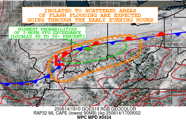
Areas affected...Portions of the OH Valley

Concerning...Heavy rainfall...Flash flooding likely

Valid 141830Z - 150030Z

SUMMARY...Slow-moving showers and thunderstorms with high rainfall
rates will likely support isolated to scattered areas of flash
flooding going through the early evening hours.

DISCUSSION...GOES-E visible satellite imagery along with area
radars are showing a continued expansion of locally heavy showers
and thunderstorms across large areas of the OH Valley, but with a
bit more of a focus along a quasi-stationary frontal zone that is
draped across the region.

MLCAPE values have risen to as high as 1500 J/kg along and just
south of this front extending from southeast IL through southern
IN. Shear parameters are minimal, but the atmosphere is very moist
with PWs of 1.6 to 1.8+ inches, and so the convective cells are
capable of producing very high hourly and sub-hourly rainfall
rates.

The convection over the next few hours should generally continue
to expand given a combination of the diurnal heating
cycle/boundary layer instability, and also the slow approach of a
wave of low pressure which is gradually traversing the front from
the west. Cyclonic low-level flow into the aforementioned front
should promote an environment where convection is at least
relatively focused along and near this boundary. However, the
steering flow is very weak with the 850/300 mb layer mean flow
generally near or under 10 kts.

This will promote slow cell-motions, and with the high moisture
profiles in place, some convective cells may be capable of
producing as much as 1.5+ inches in 30 minutes. Some spotty storm
totals of as much as 2 to 4+ inches will be possible going through
early this evening. The 12Z HREF and the 06Z REFS both depict
rather elevated probabilities (locally 40 to 50+ percent) for
seeing the 3-hour FFG exceeded across especially central/southern
IN and parts of west-central OH given the moist antecedent
conditions, and this area in particular may see notable concerns
for flash flooding going through early this evening.

Orrison

ATTN...WFO...CLE...ILN...ILX...IND...LMK...LSX...PAH...RLX...

ATTN...RFC...MSR...TIR...NWC...

LAT...LON   40528323 40048239 39208261 38628387 37978618
            37308782 37438874 38108915 38828893 39508787
            40188558
Download in GIS format: Shapefile
| KML
Last Updated: 231 PM EDT Sat Jun 14 2025
|


