| WPC Met Watch |
|
|
Mesoscale Precipitation Discussion: #0472 (2024) |
|
(Issued at 130 PM EDT Thu Jun 20 2024
) |
|
| MPD Selection |
|
|
|
|
|

Mesoscale Precipitation Discussion 0472
NWS Weather Prediction Center College Park MD
130 PM EDT Thu Jun 20 2024

Areas affected...Portions of Far Northern PA...Much of NY...New
England

Concerning...Heavy rainfall...Flash flooding possible

Valid 201730Z - 202330Z

SUMMARY...Scattered showers and thunderstorms will be developing
this afternoon across portions of northern PA, much of NY, and
across New England. High rainfall rates with the stronger storms
may result in a few instances of flash flooding.

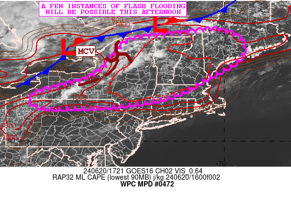
DISCUSSION...The midday GOES-E visible satellite imagery shows a
well-defined MCV exiting Lake Ontario and starting to cross
northern NY. This energy coupled more broadly with a very moist
and unstable airmass pooling ahead of a cold front approaching
from southeast Canada will set the stage for scattered showers and
thunderstorms this afternoon.

MLCAPE values are currently already on the order of 1500 to 2500
J/kg across eastern NY, NH, VT and southern ME, and with aid from
strong solar insolation and surface dewpoints in the low 70s. Some
additional uptick in instability is expected over the next couple
of hours, and this coupled with modest effective bulk shear of 20
to 25 kts, and the arriving MCV energy along with areal
orographics involving the northern Appalachians should favor pulse
and multicell convective development.

Convective initiation is well underway right now near Lake
Champlain and also farther south over south-central NY where
highly agitated CU/TCU fields are expanding in coverage.
Additional areas of far southern Quebec and approaching the higher
terrain of western ME show notable areas of CU
development/expansion.

The PWs are rather high with magnitudes locally over 1.75 inches,
and these are also as much as 2 to 3 standard deviations above
normal. This moisture coupled with the strong instability
parameters should yield thunderstorms with enhanced rainfall rates
with some rainfall rates that may reach 1.0 to 1.5 inches in as
little as 30 minutes.

Some of the 12Z HREF guidance suggests some localized 2 to 4 inch
rainfall totals, with the heaviest rains likely to focused near
the Champlain Valley and portions of the Green and White
Mountains. However, locally heavy showers and thunderstorms should
extend as far southwest as southern NY and far northern PA, and
locally heavy totals can be expected across these areas as well. A
few instances of flash flooding will be possible.

Orrison

ATTN...WFO...ALY...BGM...BOX...BTV...BUF...CAR...CTP...GYX...

ATTN...RFC...MARFC...NERFC...OHRFC...NWC...

LAT...LON   45317066 45166980 44886922 44406909 43836946
            43047091 42357215 41947365 41747525 41677645
            41637832 41767910 42167929 42557797 42927665
            43397584 44107524 44737471 44927394 45037296
            45167169
Download in GIS format: Shapefile
| KML
Last Updated: 130 PM EDT Thu Jun 20 2024
|


