| WPC Met Watch |
|
|
Mesoscale Precipitation Discussion: #0474 (2024) |
|
(Issued at 900 PM EDT Thu Jun 20 2024
) |
|
| MPD Selection |
|
|
|
|
|

Mesoscale Precipitation Discussion 0474
NWS Weather Prediction Center College Park MD
900 PM EDT Thu Jun 20 2024

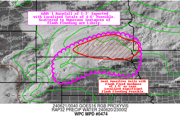
Areas affected...northern NE...southern SD...surrounding portions
of MN/IA

Concerning...Heavy rainfall...Flash flooding likely

Valid 210100Z - 210700Z

Summary...Additional rainfall of 1-3" expected with localized
totals of 4-6" possible. Given the sensitive conditions over
southeastern SD (and surroundings), scattered to numerous
instances of flash flooding are likely (with localized significant
flash flooding possible).

Discussion...A complicated evolution of convection is ongoing
across portions of the Northern/Central Plains this evening,
primarily in the vicinity of a warm front slowly lifting north
from NE into SD. The most organized convection is located over the
Sand Hills of NE, where earlier discrete cells have rapidly grown
upscale and organized into an MCS (mesoscale convective system)
with a distinct bow echo. Farther downstream, a prolific supercell
has been anchored near the warm front (nearby Ainsworth, NE), and
both surface-based (and elevated) convection is firing around (and
north) of this storm. Continued upscale growth of convection is
expected through the evening hours, as the mesoscale environment
is characterized by ML CAPE of 1000-2000 J/kg
(increasing/advecting towards the northeast), precipitable water
values of 1.4-1.8 inches (between the 90th percentile and max
moving average, per SPC sounding climatology), and effective bulk
shear 35-55 kts.

While the primary flash flood threat as of late has come from the
aforementioned supercell (which produced very impressive rainfall
rates of 2-4"/hr at its peak, per MRMS estimates), the main threat
going forward will come from training/repeating of relatively high
rainfall rates (1-2"/hr) along and north of the warm front. This
is quite problematic, as the most concerning antecedent conditions
exist across southeastern SD (and some of the immediate
surroundings of MN, IA, and NE). Much of this region has had 1-3"
(and locally 4-5") of rainfall over just the past 6-12 hours (and
anywhere from 200-600% of normal over the past 7 days). Additional
totals of 1-3" are expected (and will happen relatively quickly)
in association with the expanding MCS/bow echo, and localized
totals may reach 4-6" along the northern periphery of the MCS
where training/repeating of cells occur. Given the sensitive
conditions (with a large area of Flash Flood Guidance values of
1.5" or less), scattered to numerous instances of flash flooding
are likely (with localized significant flash flooding possible).

Churchill

ATTN...WFO...ABR...FSD...LBF...OAX...UNR...

ATTN...RFC...MBRFC...NCRFC...NWC...

LAT...LON   44779814 44329632 43249601 41699649 41929938
            41150136 41050193 41220245 42090261 43020243
            44100061
Download in GIS format: Shapefile
| KML
Last Updated: 859 PM EDT Thu Jun 20 2024
|


