| WPC Met Watch |
|
|
Mesoscale Precipitation Discussion: #0488 (2022) |
|
(Issued at 642 PM EDT Tue Jul 12 2022
) |
|
| MPD Selection |
|
|
|
|
|

Mesoscale Precipitation Discussion 0488
NWS Weather Prediction Center College Park MD
642 PM EDT Tue Jul 12 2022

Areas affected...Northern Virginia...Southern Central
Maryland...District of Columbia...

Concerning...Heavy rainfall...Flash flooding possible

Valid 122245Z - 130245Z

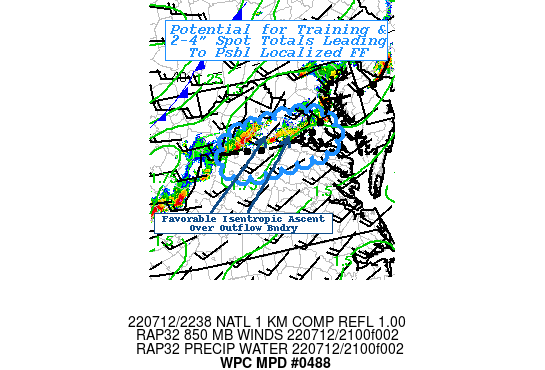
SUMMARY...Very intense short-term rain rates aligning for
favorable training/repeating resulting in possible localized flash
flooding through late evening.

DISCUSSION...Severe weather scenrio continues to unfold across the
Mid-Atlantic with very strong thunderstorms and high wind gusts.
This is also resulting in intense moisture convergence with these
cells within a very moist and unstable environment.  The mass
loading into the cells have resulted in numerous reports of 1"/30
minutes with each individual cell.   In the short-term, the
overall speed has limited flooding concerns in all but the most
prone areas, ie urban settings.

However, larger scale synoptic setup has favored the cell moving
across DC toward Annapolis MD in a very favorable placement to the
right entrance region of the jet, but the speed max is exiting
toward the northeast.   Upstream across WV a secondary subtle
speed max is starting to round the base of the upper trof.  This
has reduced the forward speed of the cold front crossing the
central Applachians resulting in a weak kink or wave around W MD.
As such, the outflow boundary from the initial storm as oriented
favorably west to east for increased west-southwesterly flow ahead
of the approaching speed max/synopic ascent.  As a result oblique
but sufficient isentropic ascent for additional similar but
slightly less intense thunderstorms have formed generally parallel
to the mean flow suggesting increased training potential across
Northern VA into southern central MD.  Given potential of
backbuilding/training as supported by recent runs of the HRRR, an
axis 2-4" totals are possible likely from Rockingham, VA toward
Prince William and across into Charles county this evening.  This
crosses a few areas of lowered FFG due to recent heavy rainfall
increasing the potential for flash flooding to occur.

Gallina

ATTN...WFO...AKQ...LWX...

ATTN...RFC...MARFC...NWC...

LAT...LON   38947703 38677651 38197659 38057776 38027883
            38317921 38817892 38937793
Last Updated: 642 PM EDT Tue Jul 12 2022
|


