| WPC Met Watch |
|
|
Mesoscale Precipitation Discussion: #0504 (2024) |
|
(Issued at 705 PM EDT Wed Jun 26 2024
) |
|
| MPD Selection |
|
|
|
|
|

Mesoscale Precipitation Discussion 0504
NWS Weather Prediction Center College Park MD
705 PM EDT Wed Jun 26 2024

Areas affected...Central Appalachians

Concerning...Heavy rainfall...Flash flooding possible

Valid 262304Z - 270500Z

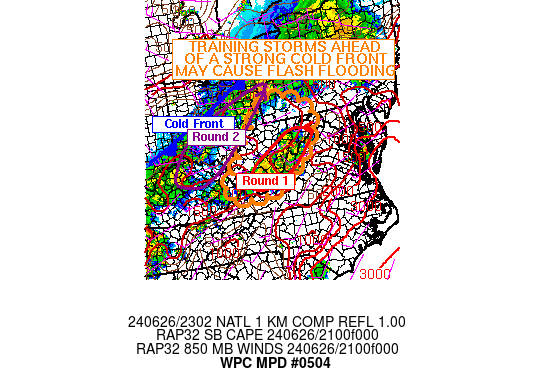
SUMMARY...An area of thunderstorms with training embedded cells
ahead of an advancing cold front may cause flash flooding through
this evening.

DISCUSSION...An area of training storms (Round 1) that has
developed on the upslope side of the central Appalachians across
much of eastern West Virginia has embedded cells with rates
approaching 2 inches per hour. This area of convection is over
parts of West Virginia where FFGs are as low as 1.5 inches per
hour. Thus, localized areas are seeing FFGs exceeded with the
stronger storms. SBCape values in eastern West Virginia are up to
1,500 J/kg with PWATs to 1.7 inches according to SPC Mesoanalysis.
This is enough instability and available moisture to sustain
storms capable of producing flash flooding given the multiple
sources of forcing for the storms.

The cold front off to the north and west (Round 2) is producing
storms with rates to 1.5 inches per hour across eastern Ohio. As
the front moves into West Virginia over the next few hours,
upslope flow off the terrain due to the northwesterly flow
associated with the front and the cooler, drier air mass behind it
will cause additional uplift along the terrain prior to the front
moving through. This is expected to locally enhance rainfall rates
over the same areas being hit with convection presently. Thus,
localized flash flooding is possible, both with the current
convection's stronger cells along with any training, as well as
with expected convection associated with the cold frontal passage
late this evening.

The cold front should be through the area by 05Z (1am), ending the
flash flooding threat.

Wegman

ATTN...WFO...CTP...JKL...LWX...PBZ...RLX...RNK...

ATTN...RFC...LMRFC...MARFC...OHRFC...NWC...

LAT...LON   40538026 40517940 40387899 39987832 38977849
            37498009 37178144 37438275 38108228 39468122
Download in GIS format: Shapefile
| KML
Last Updated: 705 PM EDT Wed Jun 26 2024
|


