| WPC Met Watch |
|
|
Mesoscale Precipitation Discussion: #0519 (2021) |
|
(Issued at 249 PM EDT Mon Jul 12 2021
) |
|
| MPD Selection |
|
|
|
|
|

Mesoscale Precipitation Discussion 0519
NWS Weather Prediction Center College Park MD
249 PM EDT Mon Jul 12 2021

Areas affected...Southern NY & Western Long Island...Northern &
Eastern PA...Northern NJ...ext Southeast CT...

Concerning...Heavy rainfall...Flash flooding possible

Valid 121850Z - 130020Z

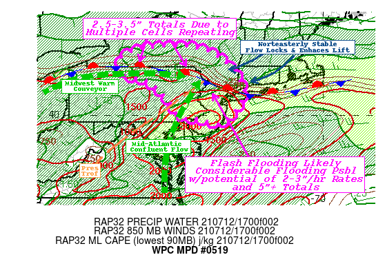
SUMMARY...Extreme rain rates across saturated grounds with
potential backbuilding/repeating pose likely flash flooding with
localized considerable flooding possible.

DISCUSSION...Eastern branch of deep layer warm conveyor becomes
fairly unidirectional and parallel from West to East across S NY/N
PA coincident with surface frontal boundary.  Embedded within the
flow are weak subtle impulses that are likely to support
short-term/transient mid to upper level UVV enhancement/support
over the next 3-6hrs, resulting in the potential for multiple
rounds of thunderstorms.  Additionally, very moist confluent flow
along/east of the Lee pressure trof across the Delaware Valley
into the Chesapeake Bay region is further amplifying low level
moisture advection into the region.  As such, 12z RAOBs at ALB/OKX
show 99th percentile of very deep moisture environment with OKX
reaching 12z daily record (2.06").   Clearing skies through the
morning have allowed for solid insolation across the area of
concern with temps already into the lower 90s from the confluent
Mid-Atlantic stream.  As such, extreme instability of 3000+ J/kg
MLCAPE and 2-2.25" Total PWats supporting the potential for 3"/hr
rates.  12z HRRR solution suggested rates of 2"/15 minutes were
possible, resulting in very high runoff across E PA into NJ/NYC
metro.   Mean steering flow should allow for propagation to limit
residency time for any given storm but HREF probabilities of 5" in
the region are around 45-50%.  This is likely due to multiple
rounds due to those transiant pulses and cells that develop along
the front across NY/PA boarder upstream.  Another concern is the
potential for cells to back-build or track along the front which
appears anchored or even slightly sagging/enhancing with
strengthening low level northeasterly flow out of New England.
All considered there is a well above average potential for
considerable flash flooding to present itself before 00z.

Further upstream, reduced but still potent unstable environment
with 1000-1500 J/kg along the front across the complex terrain of
S NY/N PA will support strong updrafts with ample deep moisture
(sfc Tds near 70 and total PWats over 1.75").  Cores are likely to
be a bit narrower but with higher potential for
repeating/training, similar likely flash flooding is clearly a
risk in much lower FFG values and more complex/steeper terrain.
Sub-hourly rates of 1.5-2"/hr resulting in similar totals with 2
or 3 rounds should support pockets of 2.5-3.5" along the front
through 00z.

Gallina

ATTN...WFO...ALY...BGM...BUF...CTP...OKX...PHI...

ATTN...RFC...MARFC...NERFC...OHRFC...NWC...

LAT...LON   42827546 42387429 41477344 40817332 40027377
            39647433 39857510 39907574 40117609 40757652
            41447732 41687829 42337841 42777738
Last Updated: 249 PM EDT Mon Jul 12 2021
|


