| WPC Met Watch |
|
|
Mesoscale Precipitation Discussion: #0528 (2022) |
|
(Issued at 231 PM EDT Mon Jul 18 2022
) |
|
| MPD Selection |
|
|
|
|
|

Mesoscale Precipitation Discussion 0528
NWS Weather Prediction Center College Park MD
231 PM EDT Mon Jul 18 2022

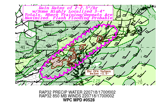
Areas affected...CT...Southern NY...NJ...Eastern PA...Central
MD...Northern& West-Central VA

Concerning...Heavy rainfall...Flash flooding possible

Valid 181830Z - 190000Z

SUMMARY...Highly efficient rainfall production with some
short-term repeating/training poses possible flash flooding
concerns, particularly across the larger urban corridor and
saturated soil conditions across MD/N VA.

DISCUSSION...GOES-E WV suite depicts elongated upper trof with
deepening lead shortwave over SE Canada, though important smaller
vorticies along the axis from W NY to KY.  Deeper moisture in the
warm conveyor belt appears to have translated over the
Appalachians and melded with surface/low level moisture in place
to allow for highly anomalous total PWat values of 2"+ increasing
to near 2.2" as further mid to upper level flow saturates the
column.  Strong insolation has also allow for these saturated
profiles to produce impressive narrow-skinny 2000-2500 J/kg MLCAPE
values along the length of the area of concern.

While the front is still well west of the area, there is
sufficient boundary layer confluence to support convective
initiation as Visible imagery indicates a few clusters north of
NYC and along the Blue Ridge, but starting to get agitated along
the remainder of the area of concern.  Due to said confluence and
deeply unidirectional southwesterly flow, individual cells will
track northeastward with some potential for next core to repeat
before slow eastward propagation advances at 5-10kts.  Given ample
moisture, rates of 2-2.5"/hr are possible resulting in similar
totals given the slower translation.  However, as mentioned above,
weak mid-level waves could support some QLCS waves that allow for
increased E-W oriented outflow boundaries that would support
streaks of enhanced duration/training and perhaps even some
backbuilding along the upwind flank of said outflow boundaries.
This will present isolated parts of the line to support locally
3-4" totals presenting higher magnitude flash flooding potential
within the longer line of AoA local FFG exceedance.

Hydrologocally: Thunderstorms along the warm front continue to
translate northward across CT into MA away from best instability
due to persistent cloud cover, but have set the stage for wetting
the grounds for additional upstream development; while other
deeply saturated soil conditions exist across Central MD into
portions of Northern VA per NASA SPoRT 10-40cm relative soil
moisture ratios around 45-60% and AHPS indicating areas of
300-500% of normal.  These area would be more at risk as well.  As
such, flash flooding is considered possible through the length of
the MPD has a whole, but there will be isolated instances of flash
flooding through the evening.

Gallina

ATTN...WFO...AKQ...ALY...BGM...BOX...CTP...LWX...OKX...PHI...
RNK...

ATTN...RFC...MARFC...NERFC...SERFC...NWC...

LAT...LON   42087388 41967270 41287269 40677341 39417530
            38517634 37167858 37447999 38817892 40137719
            41457529 41997441
Last Updated: 231 PM EDT Mon Jul 18 2022
|


