| WPC Met Watch |
|
|
Mesoscale Precipitation Discussion: #0530 (2019) |
|
(Issued at 1140 AM EDT Thu Jul 04 2019
) |
|
| MPD Selection |
|
|
|
|
|

Mesoscale Precipitation Discussion 0530
NWS Weather Prediction Center College Park MD
1140 AM EDT Thu Jul 04 2019

Areas affected...Interstate 95 corridor including northern VA,
Washington DC, MD, southeast PA

Concerning...Heavy rainfall...Flash flooding possible

Valid 041540Z - 042100Z

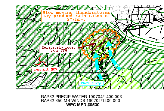
Summary...Rapidly developing but slow moving thunderstorms will
produce torrential rain this afternoon. Rainfall rates may exceed
2"/hr, during which the slow motion will allow for 1-3" of
rainfall, locally higher. This could produce flash flooding,
especially across the urban corridor where FFG is lower.

Discussion...Convection is blossoming early this morning in a
highly favorable environment ahead of a weak shortwave/MCV evident
on GOES-16 WV imagery entering West Virginia. 12Z U/A soundings
east of the Appalachians analyzed PWAT over 2 inches at most
locations south of PA, and the 2.02" observed at IAD is a daily
record. RAP forecasts suggests PWAT may climb as high as 2.25
inches across the discussion area this afternoon, which would not
only be a daily record, but approach July monthly highs. This
anomalous moisture is combining with 15Z RAP Analyzed MUCape
already exceeding 3000 J/kg, producing a thermodynamic environment
that is highly favorable for excessive rainfall.

Both satellite and regional radar show thunderstorms developing
quickly in response to the surface heating and mid-level lapse
rates of 6-7 C/km. Limited shear will inhibit storm organization
this afternoon, leaving pulse convection as the expected mode.
These storms will move very slowly in a weakly forced environment
however, and RAP Corfidi vectors fall to less than 5 kts. This
suggests nearly stationary storms with storm mergers and,
eventually, boundary collisions from outflow driving renewed
thunderstorm development. This makes it difficult to discern
exactly where the heaviest rainfall will occur as storms will
remain scattered in nature, and this is echoed by recent HRRR and
ARW guidance showing spotty heavy rain signatures over 3".
However, rainfall rates of 2"/hr on top of the relatively lowered
FFG of the urban corridor will support a flash flood risk until
the atmosphere overturns later this afternoon.

HREF 3-hr exceedance probabilities are modest, and 7-day rainfall
departures are well below normal, but these types of rain rates
could support flash flooding, especially where storms linger,
mergers occur to briefly enhance rain rates, or across the
impervious urban areas.

Weiss

ATTN...WFO...AKQ...CTP...LWX...PHI...

ATTN...RFC...MARFC...

LAT...LON   40467588 40447550 40397534 40307517 40037493
            39787486 39487487 39197499 38877526 38597548
            38477557 38247590 38027624 37887667 37907707
            38057741 38377775 38687801 38927806 39177806
            39297795 39697751 40057720 40317674 40417631
Last Updated: 1140 AM EDT Thu Jul 04 2019
|


