| WPC Met Watch |
|
|
Mesoscale Precipitation Discussion: #0553 (2019) |
|
(Issued at 600 PM EDT Sat Jul 06 2019
) |
|
| MPD Selection |
|
|
|
|
|

Mesoscale Precipitation Discussion 0553
NWS Weather Prediction Center College Park MD
600 PM EDT Sat Jul 06 2019

Areas affected...Central and Northern Mid-Atlantic

Concerning...Heavy rainfall...Flash flooding likely

Valid 062200Z - 070300Z

SUMMARY...Bands of showers and thunderstorms will focus across the
Mid-Atlantic region over the next few hours, with impacts expected
for the Philadelphia, Baltimore and Washington D.C. metropolitan
areas and adjacent suburbs involving the I-95 corridor. Flash
flooding is likely, and especially around the urban centers.

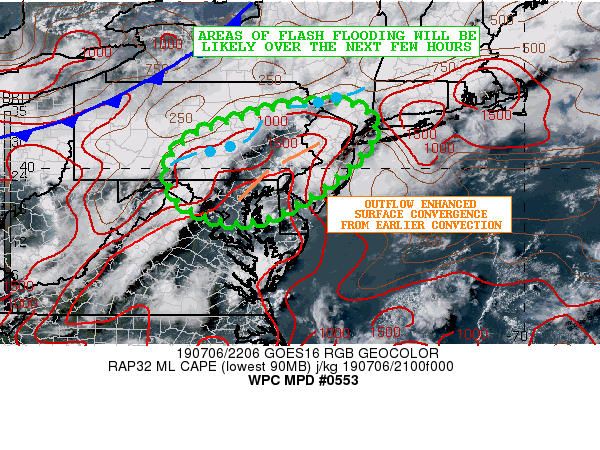
DISCUSSION...The latest radar and satellite imagery shows multiple
bands of heavy showers and thunderstorms advancing southeast
across southwest and central PA out ahead of a cold front.
Meanwhile, separate smaller clusters of convection are seen over
portions of southeast PA. The activity ahead of the cold front is
encountering a very moist and moderately unstable airmass that is
characterized by PWATs of 1.75 to 2 inches, and MLCAPE values of
1500+ j/kg. This very favorable thermodynamic environment coupled
with diffluent flow aloft around the south side of a flat upper
trough advancing across the Northeast.

However, the convection impacting areas of southeast PA is largely
attributed to locally enhanced surface convergence around the west
side of a convectively induced cold pool and associated outflow
boundary. This boundary extends from central NJ southwest across
the western suburbs of the Philadelphia metropolitan area and down
to near the Baltimore metropolitan area. The airmass from central
and northeast MD up across southeast PA is very unstable and
extremely moist with MLCAPE values of 2000 to 3000 j/kg, surface
dewpoints in the mid 70s, and overall PWATs of 2.0 to 2.25 inches.
The latest visible satellite imagery has been showing an axis of
agitated CU persisting near this boundary and certainly taking
advantage of very strong thermodynamics.

Over the next few hours, the more organized convective line
dropping southeast across southwest and central PA will encounter
this strong instability and extremely moist environment closer in
to the I-95 corridor and the adjacent western suburbs of
Philadelphia, Baltimore and Washington D.C. This coupled with the
aforementioned outflow boundary/cold pool situation will likely
allow for numerous clusters of very heavy showers and
thunderstorms to impact a large area of eastern and southeast PA,
down to areas of northeast and central MD going in closer to 00Z,
with development also possible across northern VA and around the
Washington D.C. metropolitan area. In fact, the low-level wind
field has been slowly backing over the last few hours along the
I-95 corridor and east of the Blue Ridge, which is not only
pooling stronger thermodynamics across the region, but also
facilitating greater surface convergence downstream of the cold
front as the leeside trough refocuses farther back to the west and
closer to the Blue Ridge.

The latest hires model suite of guidance including the HRRR favor
as much as 2 to 4 inches of rain locally through mid evening, of
which a large amount of that will be capable of falling in just an
hour or two. Flash flooding will be likely as a result, with the
threat enhanced especially across the urbanized I-95 corridor and
adjacent suburbia.

Orrison

ATTN...WFO...BGM...CTP...LWX...OKX...PHI...

ATTN...RFC...MARFC...NERFC...

LAT...LON   41467401 41017352 40437374 39637463 38907591
            38777690 39157796 39767832 40297821 40807758
            41297615 41447531
Last Updated: 602 PM EDT Sat Jul 06 2019
|


