| WPC Met Watch |
|
|
Mesoscale Precipitation Discussion: #0555 (2024) |
|
(Issued at 104 PM EDT Thu Jul 04 2024
) |
|
| MPD Selection |
|
|
|
|
|

Mesoscale Precipitation Discussion 0555...Corrected
NWS Weather Prediction Center College Park MD
104 PM EDT Thu Jul 04 2024

Corrected for MPD Number

Areas affected...Northern Plains...Upper Midwest

Concerning...Heavy rainfall...Flash flooding likely

Valid 041658Z - 042258Z

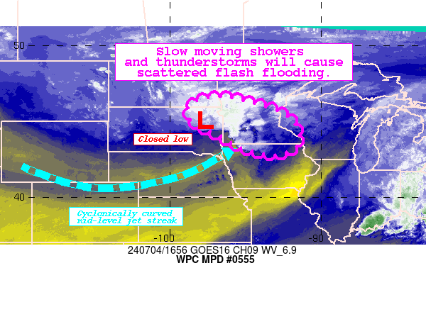
Summary...Slow moving showers and thunderstorms continue to
develop across portions of the Northern Plains and Upper Midwest.
Slow storm motions (10-15 kts) combined with 1.5-2" rainfall rates
in the most prolific cells may lead to some flash flooding this
afternoon.

Discussion...Surface and VWP data helped place a vertically
stacked low center between KABR and KMVX on the cyclonic side of a
curved mid-level jet streak entering the region. As this low
becomes increasingly defined, recent cellular activity late this
morning has exhibited an uptick in lightning density and estimated
rainfall rates of 1-1.5"/hr at times, generally along a KABR to
KFSD line.

This uptick in activity can likely be attributed to persistent
differential advection across the region (CAA aloft with
strengthening low level southerly flow) in the presence of very
divergent and diffluent upper-level pattern. Current mesoanalysis
and GPS estimates suggest 1000-2000 J/kg of MLCAPE and 1.2-1.4"
PWATS (around the 90th percentile) available to foster efficient
rainfall production, generally in a "tall-skinny" profile. Several
embedded mesoscale circulations are also noted within the larger
precipitation shield, which will locally enhance rainfall rates.

Through this afternoon, the main concern is for these efficient
showers and thunderstorms to move slowly (10-15 kts) and
regenerate near the closed low center as it meanders eastward. The
12z HREF suite remains quite aggressive with rainfall totals
(2-4") through at least 22z as the ongoing activity expands and
develops more. This is likely to result in scattered instances of
flash flooding, as much of the region is highly saturated in light
of earlier rainfall events this month. NASA SPoRT 0-100 cm soil
moisture percentiles depict soils nearly at capacity across the
region, while numerous gauges at the the West Fork Des Moines and
Mississippi River show Minor to Moderate observed flood stages. As
such, flash flooding is considered likely going into this
afternoon.

Asherman

ATTN...WFO...ABR...ARX...BIS...DMX...FGF...FSD...MPX...

ATTN...RFC...MBRFC...NCRFC...NWC...

LAT...LON   46609634 45459240 43769145 42839276 43259530
            44009642 44979846 46169858
Download in GIS format: Shapefile
| KML
Last Updated: 104 PM EDT Thu Jul 04 2024
|


