| WPC Met Watch |
|
|
Mesoscale Precipitation Discussion: #0567 |
|
(Issued at 1233 PM EDT Tue Jul 01 2025
) |
|
| MPD Selection |
|
|
|
|
|

Mesoscale Precipitation Discussion 0567
NWS Weather Prediction Center College Park MD
1233 PM EDT Tue Jul 01 2025

Areas affected...Parts of the Central Appalachians and
Mid-Atlantic

Concerning...Heavy rainfall...Flash flooding likely

Valid 011630Z - 012230Z

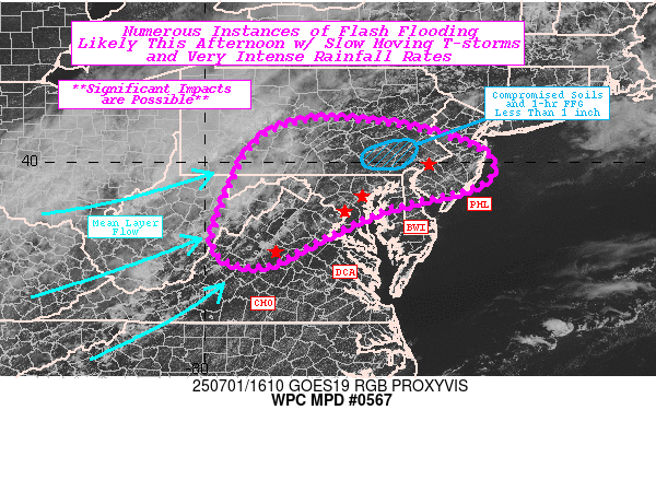
SUMMARY...Widespread showers and thunderstorms are expected this
afternoon across the central Appalachians into the Mid-Atlantic
within a very moist and unstable environment. Maximum rainfall
rates of 2-3"/hr are anticipated and may overlap with the highly
urban corridor between Washington D.C. and Philadelphia, as well
as compromised terrain in southeast PA due to heavy rainfall last
night. Numerous instances of flash flooding are likely, with some
significant imapacts possible.

DISCUSSION...GOES-East visible satellite imagery depicts a growing
cumulus field along the Blue Ridge Mts of northern/central VA
through the Mid-Atlantic, with recent LightningCast values spiking
along the Blue indicative of convective initiation imminent (seen
now on radar after 1610Z). These storms are developing ahead of an
upper trough swinging through the Midwest, prompting strengthening
west-northwesterly mean layer flow. Additionally, GOES-EAST WV-ML
highlights a disturbance off the Southeast coastline which is
helping to squeeze mid-to-upper level moisture transport towards
the central Appalachians and Mid-Atlantic. PWATs are well above
climatology (above the 90th percentile per the 00z ECENS) and even
over the daily record for IAD (12z sounding of 2.07").
Additionally, clear skies most of the morning across much of the
Mid-Atlantic has allowed for SBCAPE to increase over 4000 J/kg
from the central Chesapeake Bay northward into central NJ per
SPC's mesoanalysis. The greatest bulk shear remains to the north
over PA, but local bay/sea breezes and terrain should help
developing updrafts organize and maintain strength.

Additionally, the mean layer west-northwesterly flow will allow
for repeating cells in this direction as leading convection
eventually merges with activity progressing over the central
Appalachians. Rainfall rates are likely to be very intense within
the available environment and produce hourly rates up to 3", with
instantaneous rates even higher. The limiting factor remains if
convection can remain progressive, which would reduce the
potential rainfall totals but not limit the impacts from rainfall
rates alone. Southeast PA in particular is extremely susceptible
to these intense rainfall rates as 1-hr FFG in the area is below
1". It is this region, and the highly urbanized locations, where
significant impacts are most likely should convection overlap and
rainfall amounts maximize the available environment. Elsewhere
across the Mid-Atlantic, scattered to numerous instances of flash
flooding are also likely, but progressive west-northwesterly storm
motions should limit severity.

Snell

ATTN...WFO...AKQ...CTP...LWX...PBZ...PHI...RLX...RNK...

ATTN...RFC...RHA...TIR...NWC...

LAT...LON   40867651 40597506 40107395 39557406 39207530
            38927633 38337757 37837852 37817937 38277981
            39397947 40447886 40857783
Download in GIS format: Shapefile
| KML
Last Updated: 1233 PM EDT Tue Jul 01 2025
|


