| WPC Met Watch |
|
|
Mesoscale Precipitation Discussion: #0580 (2022) |
|
(Issued at 1259 AM EDT Mon Jul 25 2022
) |
|
| MPD Selection |
|
|
|
|
|

Mesoscale Precipitation Discussion 0580
NWS Weather Prediction Center College Park MD
1259 AM EDT Mon Jul 25 2022

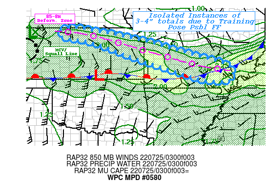
Areas affected...Northeast KS...West-Central to Southeast MO

Concerning...Heavy rainfall...Flash flooding possible

Valid 250500Z - 251100Z

SUMMARY...Isolated incidents of flash flooding are possible within
warm advection regime with NW to SE training environment.  Drier
ground conditions could help to alleviate overall potential and
reduce coverage of these incidents.

DISCUSSION...An elongated northwest to southeast northwesterly
flow regime exist between the strong upper trof over the Great
Lakes the strong Ridge in the Southwest.  A stronger than average
shortwave enhanced by MCS convective development is emerging from
the Central High Plains spurring on a broad 20-25kt LLJ across the
Southern Plains.  This is intersecting and over-running a well
defined stationary front along the KS/OK border into the
Tri-Rivers area of W KY/S IL.  From mid to upper level
reinforcement from the north, the frontal zone is starting to
increase in slope while increasing deformation zone axis from
South central Neb to central MO in the 85-8H region allowing for
increasing deep layer convergence as the southwesterly upglide
either deforms to the west across KS or stretches east into MO.
This has resulted in increased moisture pooling along the axis
with values of 2.0 to 2.3" from N KS to SE MO.  Instability is a
limiting factor with pockets of MUCAPE of 1000 J/kg within the
axis mainly from the KS/MO border southeastward, suggesting strong
convection along that portion of the WAA.  Yet, likely enhanced by
the emerging MCV strong convective development has started to fill
in across N KS, becoming more scattered toward the southeast.

Deep layer mean flow is parallel to the deformation zone and
should support cells to track along the axis with some
repeating/training to occur.  The weaker instability may allow for
narrower updraft/downdraft cores and reduce overall coverage of
likely very intense/highly efficient warm cloud processes as
WBZ/FGZ levels are around 14-16 Kft. Rates of 1.5-1.75"/hr are
possible with HRRR 15-minute totals around .5-.75".  With
increased values toward the MO given deeper moisture available and
slightly higher instability.  Given this, streaks of 2-3" are
likely with an isolated spot of 3.5-4" possible.

Another limiting factor toward incidents of flash flooding would
be due to very dry ground conditions.  NASA SPoRT relative soil
moisture values through 40cm are about 10 to 25% along the
majority of the axis with only far SE MO near 35-40%.  As such FFG
values are high and perhaps all but only the most intense cores or
longest duration of training will result in exceedance, but the
potential for isolated flash flooding slowly increases toward 09z
and later particularly further south and east along the axis.

Gallina

ATTN...WFO...EAX...GID...LSX...PAH...SGF...TOP...

ATTN...RFC...ABRFC...LMRFC...MBRFC...NCRFC...NWC...

LAT...LON   40039891 39289476 38709274 38339136 37888983
            37548943 37028953 36919024 37109165 37779372
            38109473 38619608 39269798 39539946
Last Updated: 1259 AM EDT Mon Jul 25 2022
|


