| WPC Met Watch |
|
|
Mesoscale Precipitation Discussion: #0585 |
|
(Issued at 627 AM EDT Fri Jul 04 2025
) |
|
| MPD Selection |
|
|
|
|
|

Mesoscale Precipitation Discussion 0585
NWS Weather Prediction Center College Park MD
627 AM EDT Fri Jul 04 2025

Areas affected...central TX

Concerning...Heavy rainfall...Flash flooding likely

Valid 041025Z - 041445Z

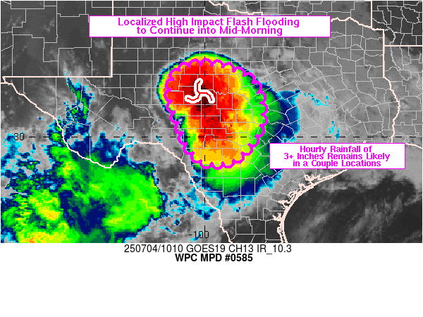
Summary...Areas of high Impact flash flooding will continue for at
least another 3-5 hour across portions of central TX. Slow to
nearly stationary net movement of heavy rain cores will maintain a
threat for hourly rainfall in excess of 3 inches in a couple of
locations. Considerable to catastrophic flash flood impacts can
continue to be expected.

Discussion...10Z radar imagery over central TX showed a cluster of
slow moving thunderstorms that extended from near San Angelo into
southern portions of the Hill Country. Embedded cells within the
cluster has exhibited near stationary movement with gauge reports
of 13+ inches about 7 miles northwest of San Angelo and 11+ inches
in Kerr County since 04Z. A long-lived embedded circulation
remained just east of San Angelo but there has been some
disruption over the past 30-60 minutes to the heavy rain cores
near San Angelo and over Kerr County. The environment remained
highly conducive to locally extreme rainfall with high freezing
levels of 15-16 kft AGL, PWs of 2.0 to 2.5 inches and up to 1000
J/kg MLCAPE via 10Z SPC mesoanalysis and RAP analysis data.

Low level convergence in the vicinity of the slow moving
circulation near San Angelo is expected to remain a focus for
localized heavy rainfall rates over the next few hours with the
axis of heaviest rainfall shifting a bit south and east in the
short term. Farther south, newer/smaller cells feeding into the
main complex over the Edwards Plateau are indicative of the
continued convergence across the region with slow net movement of
rainfall cores and MRMS-derived rainfall of 2 to 3+ inches in an
hour for a few locations in central TX. The threat for continued
higher end flash flooding is expected to remain relatively focused
across central TX over the next 3-5 hours at which point movement
of the mesoscale circulation and forecast weakening of the low
level winds into the Edwards Plateau may begin to decrease or at
least shift the heavy rain threat a bit toward the north and east.
However, through the remainder of the morning, with area creeks
and rivers rapidly rising, a very dangerous situation remains for
anybody within the highlighted MPD area. Considerable to locally
catastrophic impacts from flash flooding are likely to continue.

Otto

ATTN...WFO...EWX...FWD...MAF...SJT...

ATTN...RFC...FWR...NWC...

LAT...LON   32389983 32189901 31859845 31409817 30429813
            29799848 29239902 29159990 29490039 30230076
            31430114 31950102 32300071
Download in GIS format: Shapefile
| KML
Last Updated: 627 AM EDT Fri Jul 04 2025
|


